Auglandsbukta
| Auglandsbukta | |
|---|---|
| Neighborhood in Kristiansand | |
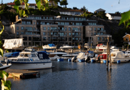 View of the neighborhood | |
 Auglandsbukta Location of the neighborhood  Auglandsbukta Auglandsbukta (Norway) | |
| Coordinates: 58°07′11″N 7°57′55″E / 58.1198°N 07.9652°ECoordinates: 58°07′11″N 7°57′55″E / 58.1198°N 07.9652°E | |
| Country | Norway |
| County | Vest-Agder |
| Municipality | Kristiansand |
| Borough | Vågsbygd |
| District | Vågsbygd |
| Elevation[1] | 0 m (0 ft) |
| Time zone | UTC+01:00 (CET) |
| • Summer (DST) | UTC+02:00 (CEST) |
| Postal code | 4621 |
| Area code | 38 |
Auglandsbukta is a neighbourhood in the city of Kristiansand in Vest-Agder county, Norway. The neighborhood is located in the borough of Vågsbygd and in the district of Vågsbygd. There is a large marina harbour and park located in the cove of Auglandsbukta. There is also a gas station and some real estate offices at Auglandsbukta. Auglandsbukta is next to Norwegian County Road 456. Augland lies to the west and Skyllingsheia lies to the north.[1]
| Line | Destination |
|---|---|
| M1 | Flekkerøy - Sørlandsparken |
| M2 | Voiebyen - Hånes |
| N2 | Kvadraturen - Voiebyen-Flekkerøy |
References
- 1 2 "Auglandsbukta, Kristiansand (Vest-Agder)". Norwegian Meteorological Institute and Norwegian Broadcasting Corporation. Retrieved 7 January 2017.
This article is issued from
Wikipedia.
The text is licensed under Creative Commons - Attribution - Sharealike.
Additional terms may apply for the media files.