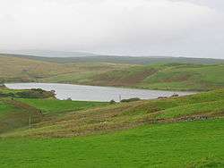
Aucha Lochy
National grid reference NR72532231
| Aucha Lochy | |
|---|---|
 | |
| Location | Campbeltown, Scotland |
| Coordinates | 55°26′39″N 5°35′47″W / 55.4443°N 5.5964°WCoordinates: 55°26′39″N 5°35′47″W / 55.4443°N 5.5964°W |
| Type | Reservoir (earth embankment dam) |
| Primary outflows | Auchalochy Burn |
| Basin countries | Scotland, United Kingdom |
| Surface area | 117,400 m2 (1,264,000 sq ft) |
| Water volume | 463,000 m3 (375 acre⋅ft) |
| Surface elevation | 97 m (318 ft) |
Aucha Lochy is an impounding reservoir, situated 1 km to the north/north east of Campbeltown and is the main source of freshwater for the town.[1] The loch is also fished by Kintyre Angling Club. The earth fill dam was completed in 1905 and has a height of 8.8 metres.
See also
Sources
This article is issued from
Wikipedia.
The text is licensed under Creative Commons - Attribution - Sharealike.
Additional terms may apply for the media files.