Attibele
| Attibele | |
|---|---|
| urban | |
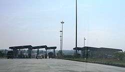 Toll Plaza and checkpost at Attibele on NH7 | |
 Attibele Location in Bangalore, India  Attibele Attibele (India) | |
| Coordinates: 12°46′36″N 77°46′08″E / 12.776800°N 77.768870°ECoordinates: 12°46′36″N 77°46′08″E / 12.776800°N 77.768870°E | |
| Country |
|
| State | Karnataka |
| District | Bangalore |
| Metro | Bengaluru |
| Government | |
| • Type | Municipal council |
| • Body | Town municipal council |
| Population | |
| • Total | 35,000 (2,012) |
| Languages | |
| • Official | Kannada |
| Time zone | UTC+5:30 (IST) |
| PIN | 562107 |
| Telephone code | +91-80 |
| Vehicle registration | KA-51,KA-59 |
| Nearest town | Anekal and Hosur |
| Lok Sabha constituency | Bangalore Urban |
| Vidhan Sabha constituency | Anekal |
Attibele is Town Municipality Council (TMC) in Anekal taluk, Bangalore Urban district Karnataka, India. The Karnataka-Tamil Nadu check post border is situated here, which is marked by an arch. It is 32 km from Bangalore and 8 km from Hosur and Anekal on NH 7. Kannada is the local language spoken here & also has some Telugu & Tamil migrant population. It also has an industrial area which has the likes of Schneider electric & many other manufacturer plants.
Transportation
- The town is well connected to Kempegowda Bus Station, K.R Market and Banashankari in Bangalore by BMTC and KSRTC buses.
- It is connected to Hosur by TNSTC Salem Division buses.
- It is also connected to Hosakote via Varthur , Whitefield and Kadugodi by BMTC buses.
From Kempegowda Bus Station and K.R Market 360 and KBS3A series buses will travel.
Jain Temple
Shri Parshwa Sushil Dham is a magnificent Jain Temple built on National Highway 7.[1] It is beautifully carved white marble temple. Here the mulnayak or the main God is "Shankeshwar Parshwanath" and a Dadavadi of "Sushil Suriji" marasaheb. Idols of Ghantakarna Mahaveer, Padmavati mata, Nakoda bhairav is also present here. This tirth has got Dharamshala, Bhojanshala, Playground for Children recreation with all modern amenities.[2]
References
| Wikimedia Commons has media related to Attibele. |
District HQ: Bangalore | |
| Villages and Towns |
|