Atlantic Hotel (Spanish Point, Ireland)


The Atlantic Hotel is a former hotel in Spanish Point, County Clare, Ireland.
The Atlantic Hotel is built around 1810 by Thomas Moroney, member of the family of local landlords. For quite a while it could boast the title Biggest Hotel on the British Isles.[2]
History
Circa 1845 Thomas Moroney extended the hotel to sixty rooms with luxurious hot and cold baths and spacious halls.[3] The quietness and luxury made it a popular refuge for Irish and English gentry.[4]
After establishing a nine-hole golf course at Spanish Point, they soon started a collaboration. While the guest of the hotel could play for free, others had to pay a green fee of 2 shilling 6 pence.[5]
Auxiliary workhouse
In 1838 the English Government issued the Irish Poor Laws to take care of the poor people and - in emergencies - to take control over destitute people. After the outbreak of the potato blight (Phytophthora infestans) and the failure of the potato crops, the system almost cracked under the pressure. Spanish Point fell under the Poor Law Union of Ennistymon. The Poor Law Union had set up a workhouse between Ennistymon and Lahinch When the real trouble broke out due to the famine, the workhouse was soon overwhelmed. The Poor Law Union leased several other big buildings, to serve as auxiliary workhouses. The Atlantic Hotel was one of them, and from September 1848 it housed 500 women and children.[6][7]
In 1893 the hotel was owned by mrs. E.L. Moroney.[8]
Leon XIII
The hotel also played a part in the story of the 1907 rescue of the Leon XIII. During a very severe storm the sail vessel Leon XIII ran on a reef near Quilty. Despite the extreme danger of storm and sea the fishermen from Quilty manned their currachs and came to the rescue. Over three days they managed to save most of the crewmembers, except the captain. Due to a broken leg he could not be moved. He was rescued later, after the storm, by a navy vessel.
The French Government was very impressed. At an event in the Atlantic Hotel the Government presented the gallant fishermen with bronze medals.[9]
Closing down
In 1930 the hotel was permanently closed down. It was largely depending on the English gentry but they did not dare to travel to Spanish Point after the Irish War of Independence and the Civil War.[10][11] The building is still mentioned in the 1942 ITA Survey, but not as a hotel.[12]
After the closure of the hotel, it went derelict and became a ruin. Nowadays just a few pieces are left.[4]
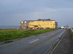
Armada Hotel
In the 1970s a new hotel started to grow on the site. This is now (2011) an 85-room hotel.[13]
References
- ↑ Limerick Museum With permission taken from the museum website under condition of mentioning the name of the museum (see name picture)
- ↑ "Historical Background". Clarelibrary.ie. 1920-04-14. Retrieved 2012-03-20.
- ↑ "Parliamentary Gazetteer of Ireland 1845". Clarelibrary.ie. Retrieved 2012-03-20.
- 1 2 "Clare-tour". Clare-tour. Retrieved 2012-03-20.
- ↑ "Golf course Spanish Point". Golfinginireland.ie. Archived from the original on 2012-03-09. Retrieved 2012-03-20.
- ↑ From a letter of Harriet Martineau, dated September 22nd., 1852. Published in The English traveller in Ireland, Harrington, John (ed.), Dublin, Wolfhound Press, 1991. Eyewitness account workhouse
- ↑ "Overcrowding in workhouses". Clarelibrary.ie. Retrieved 2012-03-20.
- ↑ "Guy's Postal Directory 1893". Clarelibrary.ie. Retrieved 2012-03-20.
- ↑ "Plaque unveiled for Quilty fishermen". Irishfrenchconnection.com. Archived from the original on 2012-03-23. Retrieved 2012-03-20.
- ↑ Paddy Casey, lecture for the "Kilfarboy Historical Society, 13-10-2009
- ↑ Talty, Brid (2013). As We Met... Local and Cultural History Kilfarboy 1880-1980 Told through the life of Martin Talty. Milltown Malbay: Brid Talty. p. 95. ISBN 9780957574304.
- ↑ I.T.A. Topographical and General Survey 1942/3
- ↑ "Armada Hotel". Armada Hotel. 2008-09-22. Retrieved 2012-03-20.
Coordinates: 52°50′41.28″N 9°26′13.39″W / 52.8448000°N 9.4370528°W