Athur, Thoothukudi
| Authoor | |
|---|---|
| panchayat town | |
 Authoor Location in Tamil Nadu, India | |
| Coordinates: 8°36′38″N 78°04′57″E / 8.610687°N 78.082468°ECoordinates: 8°36′38″N 78°04′57″E / 8.610687°N 78.082468°E | |
| Country |
|
| State | Tamil Nadu |
| District | Thoothukudi |
| Elevation | 3 m (10 ft) |
| Population (2011) | |
| • Total | 14,470 |
| Languages | |
| • Official | Tamil |
| Time zone | UTC+5:30 (IST) |
| PIN | 628151 |
| Telephone code | 04639 |
| Vehicle registration | TN69 |
| Nearest city | Thoothukudi |
| Sex ratio | 1000 : 1018.58 ♂/♀ |
| Literacy | 79% |
| Lok Sabha constituency |
Thoothukudi Formerly with Tiruchendur |
| Vidhan Sabha constituency | Tiruchendur |
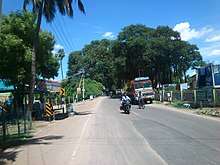
Authoor is a panchayat town in Thoothukudi district of the Indian state of Tamil Nadu.
Statistics
Demographics
As of 2011, according to the India census,[1] Authoor has a population of 14,470. 50% of the population is male, while 50% is female. Authoor has an average literacy rate of 79%, higher than the national average of 59.5%. Male literacy is 82% and female literacy is 76%. 12% of the population is under 6 years of age.
Agriculture, water and natural resources
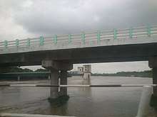
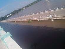
Many of the people of Authoor are farmers of betel leaf, banana and rice. The quality of betel leaf from Authoor is famous for its quality in Tamil Nadu. Authoor is also famous for the Thamirabarani river surrounding the town. The river provides a majority of the water used for irrigation in and around the area.
Authoor is a green town, surrounded by rice paddies and banana trees. The Thamirabarani River flows through the area, forming a big lake on one end. This makes the town a major attraction. The people of Authoor are generally well educated and is used as a marketplace for people in the immediate area.
Other temples
- Thousand-year-old Sri Somanatha temple is situated at Authoor
- Iyyappan temple at the end of palayagramam
- Nalla pillaiyar kovil at Authoor
- Sri Mutharamman kovil,pettai street famous temple in north authoor,Sri Santhana Mari amman temple at authoor,
- Thiruchendur Murugan Temple is the second of the Arupadai Vedu at tiruchendur(18 km)
- Sri Kailashanathar temple Sernthapoomangalam (2 km)
- Sri Vaikundanatha Perumal Temple srivaikudam (23 km)
- Kulasekaranpatinam, a village 30 km away, is known for its Dasara festival. The village has the only temple where Mutharamman is shown with his consort
Sports and games
There are no specialized grounds for youngsters at Authoor dedicated to sports or games, but, during summer, lake dries out, forming a neat green ground for the local students to play cricket and other games. Additionally, there is a small ground near the Somanathar somasundari amman temple where men play volleyball.cricket,Football
School
- Govt Higher Secondary School Authoor
- Kanchi Sankara Matriculation School, West Tiruchendur (15 km)
- Kamalavathi Higher Secondary School, Sahupuram (6 km)
- Pearl Public School CBSE, Arumuganeri (9 km)
- Lk Higher Secondary School,Kayalpatnam (8 km)
- Kayalpatinam Arumuganeri Higher Secondary School (7 km)
- Central Higher Secondary School, Kayalpantnam (8 km)
- Shanmuga Nadar Middle School, Authoor
- St.Antony's Higher Secondary School, Pazhaiyakayal(6 km)
Colleges
- Government Medical College, Tuticorin (23 km)
- Dr.Sivanthi Aditanar College of Engineering, Tiruchendur (18 km)
- Dr.G.U.Pope College of Engineering, Sawyerpuram (13 km)
- Holycross Engineering College, Tannuthu (24 km)
- Chandy College of Engineering, Mullakadu (13 km)
- Aditanar College of Arts and Science, Tiruchendur (18 km)
- Govindammal Aditanar College for Women, Tiruchendur (18 km)
- Dr. Sivanthi Aditanar College of Education, Tiruchendur (18 km)
- Dr. Sivanthi Aditanar Teacher Training Institute, Tiruchendur (18 km)
- Dr. Sivanthi Aditanar College of Physical Education, Tiruchendur (18 km)
- V.O.C Arts and Science College Tuticorin (21 km)
Transport Services
Airway:
- Domestic Airport, Vagaikullam (22 km)
Railway:
- Tuticorin railway station,(24 km)
Seaway:
- V.O.Chidambaranar Port Trust, Tuticorin (25 km)
See also
References
- ↑ "Census of India 2001: Data from the 2001 Census, including cities, villages and towns (Provisional)". Census Commission of India. Archived from the original on 2004-06-16. Retrieved 2008-11-01.