Astrolabe Island
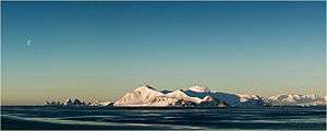
Astrolabe Island from northwest, with the Dragons Teeth on the left, and Drumohar Peak and Rogach Peak dominating the island.

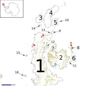
Astrolabe Island (#15) in relation to Antarctica and other peninsula islands
Astrolabe Island, located at 63°17′S 58°40′W / 63.283°S 58.667°WCoordinates: 63°17′S 58°40′W / 63.283°S 58.667°W, is an island 5 km (3 mi) long, lying in the Bransfield Strait 23 km (14 mi) northwest of Cape Ducorps, Trinity Peninsula in Antarctica. It was discovered by the French expedition, 1837–40, under Captain Jules Dumont d'Urville, and named by him for his chief expedition ship, the Astrolabe.[1] The island was photographed from the air and triangulated by FIDASE, 1956-57.
See also
Maps
- Trinity Peninsula. Scale 1:250000 topographic map No. 5697. Institut für Angewandte Geodäsie and British Antarctic Survey, 1996.
- Antarctic Digital Database (ADD). Scale 1:250000 topographic map of Antarctica. Scientific Committee on Antarctic Research (SCAR). Since 1993, regularly upgraded and updated.
References
- Astrolabe Island. SCAR Composite Antarctic Gazetteer.
Footnotes
- ↑ "Astrolabe Island". Geographic Names Information System. United States Geological Survey. Retrieved 2012-01-19.

This article is issued from
Wikipedia.
The text is licensed under Creative Commons - Attribution - Sharealike.
Additional terms may apply for the media files.