Assawoman Bay Bridge
| Assawoman Bay Bridge | |
|---|---|
 Assawoman Bay Bridge | |
| Coordinates | 38°23′17″N 75°5′14″W / 38.38806°N 75.08722°WCoordinates: 38°23′17″N 75°5′14″W / 38.38806°N 75.08722°W |
| Carries |
2 lanes of |
| Crosses | Assawoman Bay |
| Locale | Ocean City, MD |
| Maintained by | Maryland State Highway Administration |
| ID number |
|
| Characteristics | |
| Design | Box girder bridge |
| Statistics | |
| Daily traffic | 18,062[1] |
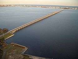
The Assawoman Bay Bridge crosses the Assawoman Bay in Ocean City, Maryland. The bridge carries Maryland Route 90, a freeway into northern Ocean City. The bridge consists of two lanes and is undivided, but is heavily travelled; as such, in the summertime, it is usually congested with traffic heading into and out of Ocean City, especially on Fridays and Sundays. It ends in North Ocean City at Maryland Route 528 (Coastal Highway) and 62nd Street.
References
- 1 2 Maryland State Highway Administration (2009). "Highway Location Reference: Worcester County" (PDF). Retrieved August 22, 2010.
External links
- Assawoman Bay Bridge map from Maryland Hometown Locator
- "Assawoman Bay Bridge". Geographic Names Information System. United States Geological Survey.
Bridges of the Assawoman Bay | ||||
|---|---|---|---|---|
| ||||
This article is issued from
Wikipedia.
The text is licensed under Creative Commons - Attribution - Sharealike.
Additional terms may apply for the media files.