Askwith
| Askwith | |
|---|---|
 Main street in Askwith looking towards Otley | |
 Askwith Askwith shown within North Yorkshire | |
| Population | 240 |
| OS grid reference | SE169482 |
| District | |
| Shire county | |
| Region | |
| Country | England |
| Sovereign state | United Kingdom |
| Post town | OTLEY |
| Postcode district | LS21 |
| Police | North Yorkshire |
| Fire | North Yorkshire |
| Ambulance | Yorkshire |
| EU Parliament | Yorkshire and the Humber |
Askwith is a village and civil parish in the Harrogate district of North Yorkshire, England, with a population of 220 (2001 census), increasing to 240 at the 2011 Census.[1] The village is located in Wharfedale, and is close to the border of West Yorkshire. Nearby towns are Otley, Ilkley and Burley-in-Wharfedale.[2] Facilities include a school,[3] a pub,[4] and a garden nursery.
An annual show is held, with attractions ranging from produce and handicraft classes, to a dog show and horse competitions, as well as stalls and entertainment.[5] There is also a WI group[6] and a toddler group.[7]
Baines lists the village as "Asquith" in 1822 and Lewis as "Askwith, or Asquith" in 1848.[8][9] It gave its name to the Asquith family including the Edwardian Liberal Prime Minister H.H. Asquith.
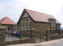
Askwith Community Primary School
The school has around 80 pupils and is constantly rated as "outstanding in Ofsted reports.
References
- ↑ "Civil Parish population 2011". Neighbourhood Statistics. Office for National Statistics. Retrieved 15 February 2016.
- ↑ Good Stuff IT Services. "Askwith, North Yorkshire | Explore Britain". explorebritain.info. Retrieved 13 April 2014.
- ↑ "Askwith Community Primary School". askwith.n-yorks.sch.uk. Retrieved 13 April 2014.
- ↑ "Black Horse Hotel : NR OTLEY, WEST YORKSHIRE, LS21 2JQ". data-leeds.co.uk. Retrieved 13 April 2014.
- ↑ "Askwith Show pulls in crowds (From Wharfedale Observer)". wharfedaleobserver.co.uk. Retrieved 13 April 2014.
- ↑ "Washburn Heritage Centre : Organisations". washburnvalley.org. Retrieved 13 April 2014.
- ↑ "Washburn Heritage Centre : Organisations". washburnvalley.org. Retrieved 13 April 2014.
- ↑ Baines, Edward, ed. (1822). History, Directory & Gazeteer, of the County of York: Vol. I. – West Riding. Leeds. p. 450. Retrieved 14 February 2018 – via archive.org.
- ↑ Lewis, Samuel, ed. (1848). "Ashurst – Aspull". A Topographical Dictionary of England. London. pp. 96–100. Retrieved 14 February 2018 – via British History Online.
External links

- Askwith in the Domesday Book