Arywee
| Arywee Airí Bhuí | |
|---|---|
| Town | |
 Arywee Location in Ireland | |
| Coordinates: 52°34′14″N 8°34′43″W / 52.57056°N 8.57861°WCoordinates: 52°34′14″N 8°34′43″W / 52.57056°N 8.57861°W | |
| Country | Ireland |
| Province | Munster |
| County | County Limerick |
| Area | |
| • Total | 0.58 km2 (0.22 sq mi) |
| Time zone | UTC+0 (WET) |
| • Summer (DST) | UTC-1 (IST (WEST)) |
Arywee is a townland in the parish of Fedamore, in County Limerick, Ireland.
Neighbouring townlands include Carnane to the west, Williamstown to the east, Parkatotaun to the north, and Cloughadoolarty South to the south.
It has an area of approximately 58 hectares (144 acres).[1] It is located 14.4 km (8.9 mi) distance by road from Limerick city centre, in a South South East direction.
The name is an anglicisation from the Irish language "Airí Bhuí", meaning "yellow milking place".[2]
Residents of Arywee entitled to vote may do so for candidates in the Castleconnell Local Electoral Area for local elections, the Limerick County constituency for general elections, South constituency for European Parliament elections. The polling station for these elections is in nearby Knockea National School.[3]
References
- ↑ IreAtlas Townland Database
- ↑ Placenames Database of Ireland
- ↑ Limerick County Council - Register of Electors Archived 2010-01-09 at the Wayback Machine.
External links
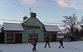 Ranch House Public House
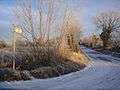 Fitzgerald Road
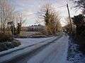 View towards Williamstown
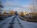 View towards Carnane