Arunawati Dam
| Arunawati Dam | |
|---|---|
 Arunavati Dam | |
 Location of Arunawati Dam in Maharashtra | |
| Official name | Arunawati Dam |
| Location | Digras |
| Coordinates | 20°07′53″N 77°44′58″E / 20.1313238°N 77.7493107°ECoordinates: 20°07′53″N 77°44′58″E / 20.1313238°N 77.7493107°E |
| Opening date | 1994 |
| Owner(s) | Government of Maharashtra, India |
| Dam and spillways | |
| Type of dam |
Earthfill Gravity |
| Impounds | Arunawati river |
| Height | 29.5 m (97 ft) |
| Length | 5,170 m (16,960 ft) |
| Dam volume | 4,412 km3 (1,058 cu mi) |
| Reservoir | |
| Total capacity | 169,675 km3 (40,707 cu mi) |
| Surface area | 39,290 km2 (15,170 sq mi) |
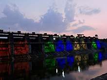
Arunawati Dam is an earthfill and gravity dam on Arunawati river near Digras in Yavatmal district of state of Maharashtra in India.
Specifications
The height of the dam above lowest foundation is 29.5 m (97 ft) while the length is 5,170 m (16,960 ft). The volume content is 4,412 km3 (1,058 cu mi) and gross storage capacity is 198,395.00 km3 (47,597.49 cu mi).[1]
Purpose
- Irrigation & Flood Control
See also
References
- ↑ Specifications of large dams in India Archived 21 July 2011 at the Wayback Machine.
This article is issued from
Wikipedia.
The text is licensed under Creative Commons - Attribution - Sharealike.
Additional terms may apply for the media files.