Armenteule
| Armenteule | ||
|---|---|---|
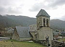 The church of Saint Félix | ||
| ||
 Armenteule Location within Occitanie region  Armenteule | ||
| Coordinates: 42°48′58″N 0°24′52″E / 42.8161°N 0.4144°ECoordinates: 42°48′58″N 0°24′52″E / 42.8161°N 0.4144°E | ||
| Country | France | |
| Region | Occitanie | |
| Department | Hautes-Pyrénées | |
| Arrondissement | Bagnères-de-Bigorre | |
| Canton | Neste, Aure et Louron | |
| Intercommunality | - | |
| Government | ||
| • Mayor (-) | - | |
| Area1 | 0.7 km2 (0.3 sq mi) | |
| Population (2013)2 | 55 | |
| • Density | 79/km2 (200/sq mi) | |
| Time zone | UTC+1 (CET) | |
| • Summer (DST) | UTC+2 (CEST) | |
| INSEE/Postal code | 65027 /65510 | |
| Elevation |
933–1,061 m (3,061–3,481 ft) (avg. 950 m or 3,120 ft) | |
|
1 French Land Register data, which excludes lakes, ponds, glaciers > 1 km2 (0.386 sq mi or 247 acres) and river estuaries. 2 Population without double counting: residents of multiple communes (e.g., students and military personnel) only counted once. | ||
.svg.png)
Armenteule is a former commune in the Hautes-Pyrénées department in southwestern France. On 1 January 2016, it was merged into the commune of Loudenvielle.[1]
Population
| Historical population | ||
|---|---|---|
| Year | Pop. | ±% |
| 1962 | 27 | — |
| 1968 | 29 | +7.4% |
| 1975 | 36 | +24.1% |
| 1982 | 32 | −11.1% |
| 1990 | 31 | −3.1% |
| 1999 | 29 | −6.5% |
| 2007 | 63 | +117.2% |
| 2009 | 61 | −3.2% |
| 2013 | 55 | −9.8% |
See also
References
- ↑ Arrêté préfectoral 21 December 2015
| Wikimedia Commons has media related to Armenteule. |
This article is issued from
Wikipedia.
The text is licensed under Creative Commons - Attribution - Sharealike.
Additional terms may apply for the media files.