Armenhoef
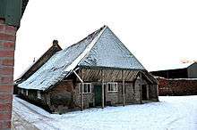
The Armenhoef is a monumental farm on the Oirschotseweg 117 in the North Brabantian town Best in the Netherlands.
The Armenhoef is the oldest, still in use farm of North Western Europe.[1] By archaeological building research in 2009 the timber frame of the barn was determined to date back to 1263.[2][3][4] The modern farmhouse itself dates from a much later period and was built in 1640 at the earliest, but probably around 1680.[5] The farm is a monument and was in urgent need of restoration. The government was prepared to provide a contribution to this restoration. Also, the building has been recognized as a monument.[6] This deviates from state policy not to designate buildings dating from the period before 1940 as a national monument.[7][8]
The name of the farm has to do with the former function. Armenhoef means Poor People Farm. The proceeds of this then-largest farm in Best were used for poor aid. The municipality has recognized the building as a municipal monument because of its cultural, historical, architectural and scenic value. Elements such as the age, the integrity of the farm and the function for poor relief played a role. To the state, the age of the farm and the rare building characteristics, such as the barn overhang above the north facade, was decisive for admission to the qualification procedure as a national monument.[9]
References
- ↑ "De oudste boerderij van West-Europa".
- ↑ "Oudste boerderij van Nederland wordt volledig 3d ingescand". Meet-Tekenwerk.nl.
- ↑ "3d laserscannen en orthofoto's oudste boerderij - Meet-Tekenwerk.nl - 3D meetoplossingen - Laser scanning - Scan to BIM". Meet-Tekenwerk.nl.
- ↑ http://www.volkskrant.nl/dossier-archief/armenhoef-blijkt-een-rijke-vondst~a3453471
- ↑ "De Armenhoef".
- ↑ "Archived copy" (PDF). Archived from the original (PDF) on 2014-09-16. Retrieved 2015-05-25.
- ↑ "Oudste boerderij wordt rijksmonument". Bouwwereld.nl.
- ↑ "Monumenten".
- ↑ Oudste boerderij van Nederland wordt rijksmonument Archived September 8, 2012, at the Wayback Machine.
External links
