Arless
| Arles Ardlios | |
|---|---|
| Village | |
 | |
 Arles Location in Ireland | |
| Coordinates: 52°53′34″N 7°01′15″W / 52.892776°N 7.020814°WCoordinates: 52°53′34″N 7°01′15″W / 52.892776°N 7.020814°W | |
| Country | Ireland |
| Province | Leinster |
| County | County Laois |
| Time zone | UTC+0 (WET) |
| • Summer (DST) | UTC-1 (IST (WEST)) |
Arles or Arless (historically Ardlisse, from Irish: Ard Lios, meaning "high ringfort")[1] is a village in County Laois, Ireland. It lies 2 km (1.24 mi) northwest of Ballickmoyler and 10 km (6.21 mi) northwest of Carlow, on the N80 national secondary road.
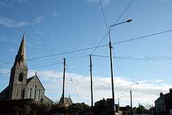
Located close to Carlow, the village has rapidly expanded in size since the 1960s, when it comprised just a few houses around the church. This was built in the 1680s (according to an inscription on a stone in the wall) and originally had a thatched roof.
Public transport
During the week the village is served by JJ Kavanagh and Sons Abbeyleix/Portlaoise-Athy-Carlow bus route with two daily journeys each way. Bus Éireann route 73 from Waterford to Athlone passes through the village but does not stop there. Rail services may be accessed at Carlow railway station.
References
- ↑ Placenames Database of Ireland (see archival records)
See also
External links
- "Village description". From Ireland. Archived from the original on 2008-05-15. Retrieved 2008-08-19.
Places in County Laois | ||
|---|---|---|
| Towns | 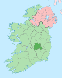 | |
| Villages and Townlands |
| |
| Landforms | ||
| ||