Arin, Armenia
Coordinates: 39°43′38″N 45°29′38″E / 39.72722°N 45.49389°E
| Arin Արին | |
|---|---|
 Arin Արին | |
| Coordinates: 39°43′38″N 45°29′38″E / 39.72722°N 45.49389°E | |
| Country | Armenia |
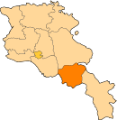
| Marz (Province) | Vayots Dzor |
| Population (2001) | |
| • Total | 264 |
| Time zone | UTC+4 ( ) |
| • Summer (DST) | UTC+5 ( ) |
Arin (Armenian: Արին; formerly Daylakhlu and Dailakhlu) is a small village in the Vayots Dzor Province of Armenia founded in the mid-19th century upon an older site.
See also
References
- Arin, Armenia at GEOnet Names Server
- Report of the results of the 2001 Armenian Census, National Statistical Service of the Republic of Armenia
- Kiesling, Brady (2005), Rediscovering Armenia: Guide, Yerevan, Armenia: Matit Graphic Design Studio
- Brady Kiesling, Rediscovering Armenia, p. 127; original archived at Archive.org, and current version online on Armeniapedia.org.
Capital: Yeghegnadzor | |||||||||||
| Urban municipalities |
|  | |||||||||
| Rural municipalities |
| ||||||||||
This article is issued from
Wikipedia.
The text is licensed under Creative Commons - Attribution - Sharealike.
Additional terms may apply for the media files.