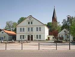
Arendsee
| Arendsee | ||
|---|---|---|
 | ||
| ||
 Arendsee Location of Arendsee within Altmarkkreis Salzwedel district _in_SAW.png) | ||
| Coordinates: 52°52′36″N 11°29′12″E / 52.8767°N 11.4867°ECoordinates: 52°52′36″N 11°29′12″E / 52.8767°N 11.4867°E | ||
| Country | Germany | |
| State | Saxony-Anhalt | |
| District | Altmarkkreis Salzwedel | |
| Government | ||
| • Mayor | Norman Klebe | |
| Area | ||
| • Total | 269.68 km2 (104.12 sq mi) | |
| Elevation | 25 m (82 ft) | |
| Population (2017-12-31)[1] | ||
| • Total | 6,722 | |
| • Density | 25/km2 (65/sq mi) | |
| Time zone | CET/CEST (UTC+1/+2) | |
| Postal codes | 39619 | |
| Dialling codes | 039003, 039034, 039036, 039384 | |
| Vehicle registration | SAW, GA, KLZ | |
| Website | www.vg-arendsee-kalbe.de | |

Arendsee (![]()
Geography
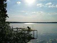
The municipality is located in the Altmark region and on the southern bank of the Arendsee lake, the largest and deepest natural lake in Saxony-Anhalt.
Municipality subdivisions
The municipality consists of the following subdivisions: Arendsee, Binde, Dessau, Fleetmark, Genzien, Gestien, Harpe, Höwisch, Kassuhn, Kaulitz, Kerkau, Kerkuhn, Kläden, Kleinau, Kraatz, Ladekath, Leppin, Lohne, Lübbars, Lüge, Mechau, Molitz, Neulingen, Rademin, Ritzleben, Sanne, Schernikau, Schrampe, Störpke, Thielbeer (an independent municipality until 1 January 2010), Vissum, Zehren, Ziemendorf, Zießau and Zühlen.
History
The locality and the lake were first mentioned in the Royal Frankish Annals in 822.
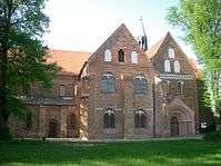
In 1184 Otto I, Margrave of Brandenburg founded a Benedictine nunnery in Arendsee while the then competent Prince-Bishop of Verden, Tammo (d. 1188), endowed it with estates.
Population development
|
|
1964–1981 census results, from 2011: 2011 European Union census[2]
References
External links

Towns and municipalities in Altmarkkreis Salzwedel | ||
|---|---|---|
| Authority control |
|---|