Area de Conservación Guanacaste World Heritage Site
| Area de Conservación Guanacaste | |
|---|---|
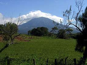 Rincón de la Vieja Volcano | |
| Location | Guanacaste Province, Costa Rica |
| Coordinates | 10°51′00″N 85°37′00″W / 10.85000°N 85.61667°WCoordinates: 10°51′00″N 85°37′00″W / 10.85000°N 85.61667°W |
| Area | 1470 km² |
| Established | 1989 |
| Governing body | National System of Conservation Areas (SINAC) |
| Type | Natural |
| Criteria | ix, x |
| Designated | 1999 (23rd session) |
| Reference no. | 928bis |
| State Party |
|
| Region | Latin America and the Caribbean |
| Extensions | 2004 |
The Area de Conservación Guanacaste is a network of protected areas and a World Heritage Site in Guanacaste Province, in northwestern Costa Rica.
Geography
The area of the national parks combined totals 1470 square kilometers as of 2004. This reflects a long-term process of growth, which started with the establishment of Santa Rosa National Park in 1971. Over several decades, surrounding lands were purchased and nearby national parks connected to the growing protected area, so that the Guanacaste Conservation Area came to encompass a high diversity of tropical dry forest, rainforest, cloud forest, and marine habitats.[1].
It formally became part of National System of Conservation Areas—SINAC in 1994, and a World Heritage site in 1999.
Elements
The World Heritage Site includes:
See also
- Guanacaste Conservation Area
- World Heritage Sites in Costa Rica
References
- ↑ Pringle, Robert M. (2017). "Upgrading protected areas to conserve wild biodiversity". Nature. 546: 91–99. doi:10.1038/nature22902. PMID 28569807.
External links
- (in English)—United Nations Environment Programme: Area de Conservación Guanacaste World Heritage Site
- (in Spanish)—Área de Conservación Guanacaste