Arch of Claudius (British victory)
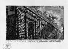

The Arch of Claudius was a triumphal arch built in honour of the emperor Claudius's successful invasion of Britain. It is now lost, although its inscription is held at the Capitoline Museums and may be seen here.[1]
The arch was dedicated in AD 51, although it was anticipated on the reverse of coins issued in AD 46-47 and AD 49. The coin shows it as surmounted by an equestrian statue between two trophies. It was a conversion of one of the arches of the Aqua Virgo aqueduct where it crossed the Via Flaminia, the main road to the north, just north of the Saepta.
The reconstructed inscription (also found on arches dedicated for the same reason at Boulogne-sur-Mer - Claudius's departure point for Britain - and at Cyzicus) reads:
| “ | The Roman Senate and People to Tiberius Claudius Caesar Augustus Germanicus, son of Drusus, Pontifex Maximus, Tribunician power eleven times, Consul five times, Imperator 22 times, Censor, Father of the Fatherland, because he received the surrender of eleven kings of the Britons defeated without any loss, and first brought barbarian peoples across the Ocean into the dominion of the Roman people.[2] | ” |
It seems to have been in ruins as early as the eighth century, but in 1562, in 1641, and again in 1869 portions of the structure were found, including part of the principal inscription, inscriptions dedicated to other members of the imperial family, some of the foundations, and fragments of sculpture of which all traces have been lost.
Sources
| Wikisource has original text related to this article: |
Primary
Secondary - coins

- The Monuments of Ancient Rome as Coin Types (1989) by Philip V. Hill
- Freeman & Sear Catalog No.12 (2005), item 536.
- BM Claud. 29, 32‑35, 49‑50
- Cohen, Claudius 16‑24
- HJ 468‑9; LS III.125‑6
- PBSR III.220‑223
Secondary - inscriptions
- Corpus Inscriptionum Latinarum (CIL) VI.920‑923 = 31203‑4
Secondary - other
- For reliefs discovered in the 1920s which may belong to it, see Notizie degli Scavi 1925, 230‑233; Bocconi, Musei Capitolini, 292.9; 294.14; YW 1925‑6, 112.
References
- ↑ M. K. Thornton; R. L. Thornton (1989). Julio-Claudian Building Programs: A Quantitative Study in Political Management. Bolchazy-Carducci Publishers. pp. 138–. ISBN 978-0-86516-202-0.
- ↑ CIL VI 40416 = CIL VI 920 = CIL VI 31203 = AE 1948, 80 = AE 2004, 38
External links
- Arch of Claudius at Encyclopædia Romana project (University of Chicago)
This article contains text from Platner and Ashby's A Topographical Dictionary of Ancient Rome, a text now in the public domain.
Coordinates: 41°53′58″N 12°28′52″E / 41.89932°N 12.48110°E