Aray, Lebanon
| Aray عراي | |
|---|---|
| Village | |
 Aray Location within Lebanon | |
| Coordinates: 33°32′0″N 35°35′0″E / 33.53333°N 35.58333°ECoordinates: 33°32′0″N 35°35′0″E / 33.53333°N 35.58333°E | |
| Country |
|
| Governorate | South Governorate |
| District | Jezzine District |
| Time zone | UTC+2 (EET) |
| • Summer (DST) | UTC+3 (EEST) |
| Dialing code | +961 |
Etymology
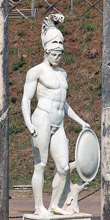
Aray is named in honor of Ares, God of Warfare
The name of the village, Aray, is derived from the Greek god of warfare, Ares.
Agriculture
Aray is a regional producer of grapes, olives, pines, and jujube.
Industry
Aray is a major producer of olive-oil and olive-oil soap as well as pine nuts.
Geography
Aray lies on a mountaintop, overlooking Jezzine and the Bkassine forest. Aray is rich in springs and streams, especially the Aray Stream, which is the principal tributary of the Awali river in South Lebanon.
External links
- Aaray, Localiban
Capital: Jezzine | ||
| Towns and villages | 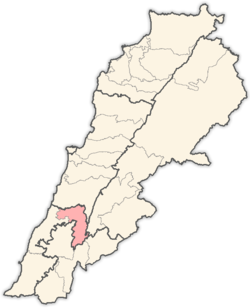 | |
This article is issued from
Wikipedia.
The text is licensed under Creative Commons - Attribution - Sharealike.
Additional terms may apply for the media files.