Aratz
| Aratz | |
|---|---|
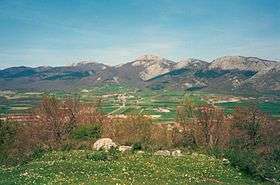 Aratz seen from the Llanada Alavesa plains. | |
| Highest point | |
| Elevation | 1,443 m (4,734 ft) |
| Coordinates | 42°55′19.34″N 02°18′13.17″W / 42.9220389°N 2.3036583°WCoordinates: 42°55′19.34″N 02°18′13.17″W / 42.9220389°N 2.3036583°W |
| Naming | |
| Translation | Pure (Basque) |
| Pronunciation | Basque: [aˈɾats̻] |
| Geography | |
 Aratz Location in Spain | |
| Location | Álava, Spain |
| Parent range | Basque mountains, Altzania |
| Climbing | |
| Easiest route | From San Adrian/Ezkaratza spring |
Aratz (meaning 'pure' in Basque, after its stone surface devoid of vegetation) is a mountain of the Basque Country in Spain located at the mountain range Altzania (also called Urkilla) that provides the extension for the massif Aizkorri. It lies right on the line between provinces Gipuzkoa and Álava, the summit rising at 1,443 m high, next to Elurzuloak (1,431 m). The whole Aizkorri and Aratz area was declared the Aizkorri-Aratz Natural Park in 2006.[1][2]
Access points and trails
The main access points are located both in the town of Araia on the fringes of the Alava plains (840 m drop from the summit) and at the spring Ezkaratza (drinking water) by the Way of St James west of the San Adrian tunnel.
- The route starting off in Araia (PR-A11) heads north past the ruins of the fortress Marutegi on a rock halfway (8th century). Soon after, the trail with yellow and white signalization must be abandoned right to get to the spring Iturriotz (1h10, drinking water), and on to the switching point with both GR-121 and PR-A12 coming from Ezkaratza. The summit of Aratz lies on the south-east after surmounting steep limestone karst slopes with no clear trail (1h45).
- From Ezkaratza, some minutes away from the pass of San Adrian, the PR-A12 circuit trail penetrates south-east up into the forest until it merges with GR-121 (red and white signalization) and the above route coming from Araia.
- A third but less popular route sets off in Beunda on the way to San Adrian. The concrete track winds down west until the milestone Aldaola where it forks (altitude 850 m). The option is to follow the left track, which going down reaches and crosses the stream. At this point, the northern face of Aratz towers on the left covered with a vast beech forest. In no more than 150 metres, the track veers sharply to the east and on to south-east until the pass of Allarte (1,141 m high) is reached.
References
- ↑ "Aizkorri-Aratz Natural Park", in the website of the Government of the Basque Autonomous Community.
- ↑ (in Basque)(in Spanish) 76/2006 Decree of the Government of the Basque Autonomous Community, declaring Aizkorri-Aratz a Natural Park, 4 April 2006.
External links
- Description of some accesses to Aratz (Archived 2009-10-25) Site in Spanish
This article is issued from
Wikipedia.
The text is licensed under Creative Commons - Attribution - Sharealike.
Additional terms may apply for the media files.