Araguari River (Amapá)
| Araguari River | |
|---|---|
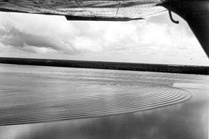 Undular bore and whelps near the mouth of Araguari River. View is oblique toward mouth from airplane at approximately 100 ft (30 m) altitude.[1] | |
 | |
| Native name | Rio Araguari |
| Country | Brazil |
| Physical characteristics | |
| Main source | Amapá state |
| River mouth |
Atlantic Ocean 1°15′00″N 49°55′00″W / 1.25°N 49.916667°WCoordinates: 1°15′00″N 49°55′00″W / 1.25°N 49.916667°W |
| Length | 560 kilometres (350 mi)[2] |
| Basin features | |
| Basin size | 42,712 square kilometres (16,491 sq mi) |
| Tributaries |
|
The Araguari River (Portuguese: Rio Araguari River) is the primary river of Amapá state in north-eastern Brazil. It became famous among surfers when some decided to ride its constant tidal bore, characterizing waves that can last for several minutes.[3]
The river flows through the Uatuma-Trombetas moist forests ecoregion.[4] The river defines the western boundary of the 460,353 hectares (1,137,560 acres) Amapá National Forest, a sustainable use conservation unit created in 1989.[5]
See also
References
- ↑ Figure 5 in: Susan Bartsch-Winkler; David K. Lynch (1988), Catalog of worldwide tidal bore occurrences and characteristics (Circular 1022), U. S. Geological Survey
- ↑ Ziesler, R.; Ardizzone, G.D. (1979). "Amazon River System". The Inland waters of Latin America. Food and Agriculture Organization of the United Nations. ISBN 92-5-000780-9. Archived from the original on 8 November 2014.
- ↑ Surfers Village "Big-Wave Tow-in surfers on mile-long Pororoca wave"
- ↑ Sears, Robin, Northern South America: Northeastern Brazil, into southern Guyana and Suriname (NT0173), WWF: World Wildlife Fund, retrieved 2017-03-31
- ↑ FLONA do Amapá (in Portuguese), ISA: Instituto Socioambiental, retrieved 2016-07-06
This article is issued from
Wikipedia.
The text is licensed under Creative Commons - Attribution - Sharealike.
Additional terms may apply for the media files.