Ajo Colluna
| Ajo Colluna | |
|---|---|
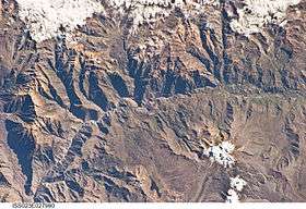 The Colca River as seen from the ISS. Ajo Colluna in the upper right edge of this image is hidden beneath a cloud. | |
| Highest point | |
| Elevation | 5,255 m (17,241 ft) [1] |
| Coordinates | 15°29′33″S 71°40′29″W / 15.49250°S 71.67472°WCoordinates: 15°29′33″S 71°40′29″W / 15.49250°S 71.67472°W |
| Geography | |
 Ajo Colluna Peru | |
| Location | Peru, Arequipa Region |
| Parent range | Andes, Chila |
Ajo Colluna (possibly from Quechua aqu sand, kulluna washbowl; silo,[2] "sand bowl" or "sand silo") is a 5,255-metre-high (17,241 ft) mountain in the Chila mountain range in the Andes of Peru. It is located in the Arequipa Region, Caylloma Province, on the border of the districts of Lari and Tuti. It lies northeast of Quehuisha and Mismi.[3]
References
- ↑ "Nevado Ajo Colluna". IGN, Peru. Archived from the original on May 25, 2015. Retrieved May 25, 2015.
- ↑ Teofilo Laime Ajacopa, Diccionario Bilingüe Iskay simipi yuyayk'ancha, La Paz, 2007 (Quechua-Spanish dictionary)
- ↑ escale.minedu.gob.pe - UGEL map of the Caylloma Province 1 (Arequipa Region)
This article is issued from
Wikipedia.
The text is licensed under Creative Commons - Attribution - Sharealike.
Additional terms may apply for the media files.