Apacheta (Arequipa)
| Apacheta | |
|---|---|
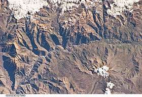 The Colca River and Apacheta northwest of it (upper left) as seen from the ISS | |
| Highest point | |
| Elevation | 5,328 m (17,480 ft) [1] |
| Coordinates | 15°23′03″S 72°10′44″W / 15.38417°S 72.17889°WCoordinates: 15°23′03″S 72°10′44″W / 15.38417°S 72.17889°W |
| Geography | |
 Apacheta Peru | |
| Location | Peru, Arequipa Region, Castilla Province |
| Parent range | Andes, Chila |
Apacheta (possibly from Aymara for the place of transit of an important pass in the principal routes of the Andes; name for a stone cairn in the Andes, a little pile of rocks built along the trail in the high mountains)[2][3] is a 5,328-metre-high (17,480 ft) mountain in the western part of the Chila mountain range in the Andes of Peru. It lies in the Arequipa Region, Castilla Province, Chachas District. It is situated southwest of Chila, northeast of Chila Pillune and southeast of Yuaytacondorsenja.
Apacheta lies at the bank of the Cacamayo (possibly from Quechua for "rock river"). Its waters flow to the Molloco River in the east, a right affluent of the Colca River.[1][4]
References
- 1 2 "Cerro Apacheta". IGN, Peru. Archived from the original on May 27, 2015. Retrieved May 27, 2015.
- ↑ Radio San Gabriel, "Instituto Radiofonico de Promoción Aymara" (IRPA) 1993, Republicado por Instituto de las Lenguas y Literaturas Andinas-Amazónicas (ILLLA-A) 2011, Transcripción del Vocabulario de la Lengua Aymara, P. Ludovico Bertonio 1612 (Spanish-Aymara-Aymara-Spanish dictionary)
- ↑ Teofilo Laime Ajacopa, Diccionario Bilingüe Iskay simipi yuyayk'ancha, La Paz, 2007 (Quechua-Spanish dictionary)
- ↑ escale.minedu.gob.pe - UGEL map of the Caylloma Province 1 (Arequipa Region)
This article is issued from
Wikipedia.
The text is licensed under Creative Commons - Attribution - Sharealike.
Additional terms may apply for the media files.