Anthropomorphic maps
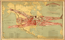
The Man of Commerce, 1889, Rand McNally and Company
Anthropomorphic maps are maps that use anthropomorphic images. Anthropomorphic maps date back to when Sebastian Münster used a queen to depict Europe in 1570.[1] The map, The Man of Commerce, by Augustus F. McKay is the earliest anthropomorphic map known of in the United States, created in 1889.[1]
References
- 1 2 "The Man of Commerce". World Digital Library. 1889. Retrieved 2013-07-28.
This article is issued from
Wikipedia.
The text is licensed under Creative Commons - Attribution - Sharealike.
Additional terms may apply for the media files.