Antelope Flat Reservoir
| Antelope Flat Reservoir | |
|---|---|
 Antelope Flat Reservoir | |
| Location | Crook County, Oregon |
| Coordinates | 44°00′16″N 120°23′37″W / 44.00458°N 120.39361°WCoordinates: 44°00′16″N 120°23′37″W / 44.00458°N 120.39361°W |
| Type | reservoir |
| Primary inflows | Bear Creek |
| Primary outflows | Bear Creek |
| Surface area | 170 acres (69 ha) |
| Average depth | 11 feet (3.4 m) |
| Max. depth | 28 feet (8.5 m) |
| Water volume | 2,000 acre feet (2,500,000 m3) |
| Surface elevation | 4,984 feet (1,519 m) |
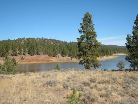
Antelope Flat Reservoir is an impoundment located in the southern part of the Maury Mountains in Crook County, Oregon. It is formed by a 33-foot (10 m) high earth-fill dam built across Bear Creek for irrigation purposes. The western part of the lake is within the Ochoco National Forest. Though it covers 170 acres (69 ha) when full, and has a storage capacity of almost 2,000 acre feet (2,500,000 m3) with a maximum depth of 28 feet (8.5 m) and average depth of 11 feet (3.4 m), the reservoir is often not filled to capacity, especially late in the irrigation season [1]. The lake resides at an elevation of 4,984 feet (1,519 m)[2]. A boat-launch ramp is located at the lake's western end, and a 25-unit campground lies just up the hill from there.
Fish in the reservoir include rainbow trout and catfish. A rotenone treatment was applied in 2009 in an effort to remove brown bullhead catfish [3]
See also
References
- ↑ "Antelope Flat Reservoir (Crook County)". Portland State University. Retrieved March 30, 2018.
- ↑ U.S. Geological Survey Geographic Names Information System: Antelope Flat Reservoir
- ↑ Bend Bulletin