Ano Vrontou
| Ano Vrontou Άνω Βροντού | |
|---|---|
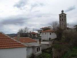 View from Ano Vrontou | |
 Ano Vrontou Location within the regional unit 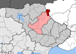 | |
| Coordinates: 41°18′N 23°41′E / 41.300°N 23.683°ECoordinates: 41°18′N 23°41′E / 41.300°N 23.683°E | |
| Country | Greece |
| Administrative region | Central Macedonia |
| Regional unit | Serres |
| Municipality | Serres |
| • Municipal unit | 47.3 km2 (18.3 sq mi) |
| Elevation | 1,040 m (3,410 ft) |
| Population (2011)[1] | |
| • Municipal unit | 199 |
| • Municipal unit density | 4.2/km2 (11/sq mi) |
| Time zone | UTC+2 (EET) |
| • Summer (DST) | UTC+3 (EEST) |
| Postal code | 621 00 |
| Vehicle registration | ΕΡ |
Ano Vrontou (Greek: Άνω Βροντού; Macedonian: Горно Броди; Bulgarian: Горно Броди, Gorno Brodi) is a remote mountain village and a former community in the northern Serres regional unit, Greece. Since the 2011 local government reform it is part of the municipality Serres, of which it is a municipal unit.[2] The municipal unit has an area of 47.306 km2.[3] In 2011 its population was 199. Ano Vrontou is situated in the northeastern part of the Vrontous mountains, at about 1060 m elevation. It borders on the Drama regional unit to the north and east. Ano Vrontou is 6 km northwest of Kato Vrontou, 12 km east of Achladochori, 13 km northeast of Oreini, 16 km southwest of Kato Nevrokopi and 26 km northeast of Serres.
Population
| Year | Population |
|---|---|
| 1873 | 2,700 |
| 1900 | 6,700 |
| 1981 | 347 |
| 1991 | 408 |
| 2001 | 452 |
| 2011 | 199 |
History
The finding of a Greek inscription of Roman (Imperial) times supports the conclusion that in the place of the present village there was an ancient settlement, whose residents were engaged in the exploitation of the iron mines of the mountain Vrontous.[4]
Brodi (now Vrontou) was first mentioned in the 14th century in a letter from the Serbian tsar Stefan Dušan to Rayko, the ruler of Brodi and Trilisa (now Vathytopos). The Ottomans conquered the area and ruled until the Balkan Wars. Prior to the Second Balkan Wars, it had a Bulgarian majority and a Turkish minority.
It had around 2,700 Bulgarian inhabitants in 1873.[5] By 1900, its population rose to 6,100 Bulgarian Christians. In 1905 according to the secretary of the exarch Dimitar Mishev the settlement had around 6,480 Bulgarian exarchists and 240 Bulgarian patriarchists, making it one of the largest places in the area.[6]
The village had a large activity by VMORO in an Ottoman province. In 1903, the large settlement was visited by Gotse Delchev from the Vanisha. In 1913, it had 1,100 houses and 8,000 inhabitants. In the Balkan Wars, the area was conquered and occupied by Greece and its residents fled northward to Bulgaria, 200 of them to Nevrokop (now Gotse Delchev) and 300 fled to Plovdiv. They were replaced by Greeks that fled from Asia Minor and Eastern Thrace during the Greco-Turkish War (1919-1922).
Notable people
- Dimo Hadjidimov, Internal Macedonian Revolutionary Organization (IMRO) revolutionary leader
- Tasos Stambouloglou (b. 1938), Greek poet and literary critic
- Georgi Sivkov (1909–1964) Leader of the Bulgarian Fatherland Front Otechstven Front
Literature
- Vasil Kanshov on Ano Vrontou (Gorno Brodi)
- Georgi Bazhdarov Gorno Brodi (Горно Броди or Ano Vrontou), Sofia, 1929
- Vidoeski, Bozhidar Gorno Vrodi, Drama, Skopje, 1992 XVII 2, p 5-89
See also
References
- ↑ "Απογραφή Πληθυσμού - Κατοικιών 2011. ΜΟΝΙΜΟΣ Πληθυσμός" (in Greek). Hellenic Statistical Authority.
- ↑ Kallikratis law Greece Ministry of Interior (in Greek)
- ↑ "Population & housing census 2001 (incl. area and average elevation)" (PDF) (in Greek). National Statistical Service of Greece. Archived from the original (PDF) on 2015-09-21.
- ↑ Dimitrios C. Samsaris, A History of Serres (in the Ancient and Roman Times) (in Greek), Thessaloniki 1999, p. 167-168 (Website of Municipality of Serres)
- ↑ Ethnographie des Vilayets d'Andrinople, de Monastir et de Salonique, 1878, reprint in Bulgarian: „Македония и Одринско. Статистика на населението от 1873 г.“ Macedonian Scientific Institute, Sofia, 1995, pp. 116-117
- ↑ Brancoff, D.M. La Macédoine et sa Population Chrétienne, Paris, 1905, pp. 198-199
External links
Places adjacent to Ano Vrontou | ||||||||||
|---|---|---|---|---|---|---|---|---|---|---|
| ||||||||||