Anilio, Ioannina
| Anilio Ανήλιο | |
|---|---|
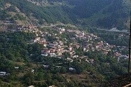 A view of Anilio. | |
 Anilio | |
| Coordinates: 39°45.55′N 21°11.3′E / 39.75917°N 21.1883°ECoordinates: 39°45.55′N 21°11.3′E / 39.75917°N 21.1883°E | |
| Country | Greece |
| Administrative region | Epirus |
| Regional unit | Ioannina |
| Municipality | Metsovo |
| Municipal unit | Metsovo |
| Elevation | 1,050 m (3,440 ft) |
| Community[1] | |
| • Population | 587 (2011) |
| • Area (km2) | 42.637 |
| Time zone | UTC+2 (EET) |
| • Summer (DST) | UTC+3 (EEST) |
| Postal code | 442 00 |
| Area code(s) | +30-2656-xxx-xxx |
| Vehicle registration | ΙΝx-xxxx |
Anilio (Greek: Ανήλιο, Aromanian: Chiarã) is an Aromanian (Vlach) village and a community of the Metsovo municipality.[1] Since the 2011 local government reform it is part of the municipality Metsovo, of which it is a municipal district.[2] The 2011 census recorded 587 residents in Anilio.[1] The community of Anilio covers an area of 42.637 km2.[3]
See also
References
- 1 2 3 "Απογραφή Πληθυσμού - Κατοικιών 2011. ΜΟΝΙΜΟΣ Πληθυσμός" (in Greek). Hellenic Statistical Authority.
- ↑ Kallikratis law Greece Ministry of Interior (in Greek)
- ↑ "Population & housing census 2001 (incl. area and average elevation)" (PDF) (in Greek). National Statistical Service of Greece. Archived from the original (PDF) on 2015-09-21.
This article is issued from
Wikipedia.
The text is licensed under Creative Commons - Attribution - Sharealike.
Additional terms may apply for the media files.