Angelino Heights, Los Angeles
| Angelino Heights | |
|---|---|
| Neighborhood of Los Angeles | |
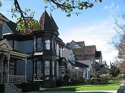 Victorian houses in Angelino Heights | |
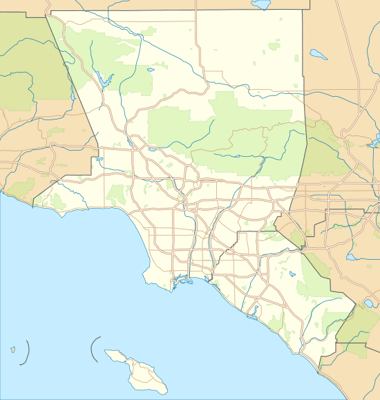 Angelino Heights Location in Los Angeles | |
| Coordinates: 34°04′13″N 118°15′17″W / 34.07028°N 118.25472°WCoordinates: 34°04′13″N 118°15′17″W / 34.07028°N 118.25472°W | |
| Country | United States |
| State | California |
| County | Los Angeles County |
| City | Los Angeles |
| Elevation[1] | 502 ft (153 m) |
Angelino Heights is one of the oldest neighborhoods in Los Angeles, California, situated within neighboring districts of Chinatown and Echo Park. This neighborhood is known for its concentration of eclectic architectural styles from three eras: The Victorian, Turn of the Century and Revival eras.[2]
Location
The Angelino Heights neighborhood is situated on a hill of about 502 feet in elevation,[3] located within the Echo Park and Chinatown proper. The neighborhood’s boundaries include the 101 Hollywood freeway to the south, Sunset Boulevard to the north and east, and Echo Park Lake to the west. Sunset Boulevard is the main thoroughfare that connects and services all three districts.[2]
The neighborhood
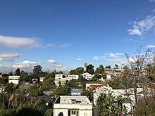
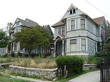
Originally spelled Angeleno Heights, Angelino Heights is second only to Bunker Hill as the oldest district in Los Angeles outside of Downtown. Founded in 1886, it was originally connected to the downtown mainline (which ran east to west on Temple Street) by the Temple Street Cable Railway and later by streetcars. Like Echo Park proper and Chinatown, it is known for its steep hills. The district contains many notable examples of Victorian architecture, particularly of the Eastlake and Queen Anne styles, and though found throughout the neighborhood, they are especially concentrated on Carroll Avenue. Two of these residences served as the houses used for the TV shows Charmed and Journeyman, used in the shows as San Francisco Victorian residences, and because of the picturesque nature of the neighborhood, they have served as the backdrop for countless motion pictures from the earliest days of cinema to the present. Traveling around the neighborhood, one also discovers that many other styles of architecturally significant homes are to be found here, such as Craftsman, Bungalow, Mission Revival, Art Deco, and Colonial Revival, to name a few.
A large swath of Angelino Heights was destroyed to build the Hollywood Freeway, which cut it off from Temple Street save an overpass at Edgeware Road.
Angelino Heights was the City of Los Angeles' first recognized historic district, or Historic Preservation Overlay Zone (HPOZ). Enacted in 1983 and spelled out in Angelino Heights' Preservation Plan, this zoning prohibits unsympathetic remodelling of historic houses and requires new construction to resemble original architecture in scale, massing and materials.
Police service
The Los Angeles Police Department operates the Rampart Community Police Station, which was located at 2710 West Temple Street, 90026, serving the neighborhood.[4] It has since moved east into a newly constructed facility at 1401 West 6th Street, the site of the former emergency receiving hospital.
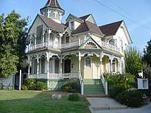
The Sanders House
The house that sits at 1345 Carroll Ave in Angelino Heights is known as the Sanders House and is most famous for being featured as the spooky setting for Michael Jackson's Thriller music video.The 3,532-square-foot Queen Anne style house was originally built for a local warehouse operator named Michael Sanders in 1887. [5]
The Sanders House was also featured in a Season 4 episode of Charmed, as well as the movie Teen Witch (1989). [5]
Education
Angelino Heights is zoned to Los Angeles USD schools.[6]
All residents are zoned to Plasencia Elementary School.
Some residents are zoned to King Middle School, while some are zoned to Virgil Middle School.
All residents are zoned to Belmont High School.
See also
References
- ↑ U.S. Geological Survey Geographic Names Information System: Angelino Heights, Los Angeles
- 1 2 City of Los Angeles, Planning Department (10 June 2004). "Angelino Heights Preservation Plan". preservation.lacity.org. Retrieved April 20, 2018.
- ↑ "Angelino Heights Topo Map, Los Angeles County CA (Hollywood Area)". TopoZone. Retrieved 2018-04-21.
- ↑ "Rampart Community Police Station - Los Angeles Police Department". www.lapdonline.org.
- 1 2 "Scene It Before: The Thriller House Los Angeles Magazine". Los Angeles Magazine. 2014-10-30. Retrieved 2018-10-08.
- ↑ Mena, By Jennifer. "Preserving L.A.'s past in Angelino Heights - Los Angeles Times". latimes.com.
External links
| Wikimedia Commons has media related to Angelino Heights, Los Angeles. |
- Los Angeles Times, West Magazine: "Angelino Heights" (12 Feb 2006)Los Angeles Times, Real Estate section, Neighborly Advice column: "Preserving L.A.'s past in Angelino Heights" (13 Feb 2005)
- Angelino Heights Trolley Line
- Historic 1300 Carroll Avenue/Morales House
- Angelino Heights Photo Gallery
| By topic |  | |
|---|---|---|
| Government | ||
| Districts and neighborhoods | ||
|---|---|---|
| Points of interest | ||
| Neighboring cities | ||