Anavyssos
| Anavyssos Ανάβυσσος | |
|---|---|
 Anavyssos Location within the regional unit 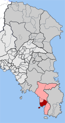 | |
| Coordinates: 37°44′N 23°57′E / 37.733°N 23.950°ECoordinates: 37°44′N 23°57′E / 37.733°N 23.950°E | |
| Country | Greece |
| Administrative region | Attica |
| Regional unit | East Attica |
| Municipality | Saronikos |
| • Municipal unit | 14.478 km2 (5.590 sq mi) |
| Elevation | 15 m (49 ft) |
| Population (2011)[1] | |
| • Municipal unit | 6,202 |
| • Municipal unit density | 430/km2 (1,100/sq mi) |
| Time zone | UTC+2 (EET) |
| • Summer (DST) | UTC+3 (EEST) |
| Postal code | 190 13 |
| Area code(s) | 22910 |
| Vehicle registration | Z |
Anavyssos (Greek: Ανάβυσσος) is a town and a former municipality in East Attica, Greece. Since the 2011 local government reform it is part of the municipality Saronikos, of which it is a municipal unit.[2] The municipal unit has an area of 14.478 km2.[3] At the 2011 census it had 6,202 inhabitants.[1]
It is situated near the Saronic Gulf coast, at the foot of the Olympos hill (487 m). It is 2 km north of Palaia Fokaia, 4 km east of Saronida, 10 km west of Lavrio and 34 km southeast of Athens city centre. The Greek National Road 91 (Athens - Sounion) passes south of the town, along the coast.
Historical population
| Year | Population |
|---|---|
| 1981 | 2,383 |
| 1991 | 4,108 |
| 2001 | 7,189 |
| 2011 | 6,202 |
See also
References
- 1 2 "Απογραφή Πληθυσμού - Κατοικιών 2011. ΜΟΝΙΜΟΣ Πληθυσμός" (in Greek). Hellenic Statistical Authority.
- ↑ Kallikratis law Greece Ministry of Interior (in Greek)
- ↑ "Population & housing census 2001 (incl. area and average elevation)" (PDF) (in Greek). National Statistical Service of Greece. Archived from the original (PDF) on 2015-09-21.
External links
| ||||||||||
This article is issued from
Wikipedia.
The text is licensed under Creative Commons - Attribution - Sharealike.
Additional terms may apply for the media files.