De Vlugtlaan metro station
De Vlugtlaan | |||||||||||
|---|---|---|---|---|---|---|---|---|---|---|---|
 | |||||||||||
| Location | Netherlands | ||||||||||
| Coordinates | 52°22′46″N 4°50′17″E / 52.37944°N 4.83806°ECoordinates: 52°22′46″N 4°50′17″E / 52.37944°N 4.83806°E | ||||||||||
| History | |||||||||||
| Opened | 1 June 1997 | ||||||||||
| Services | |||||||||||
| |||||||||||
| Location | |||||||||||
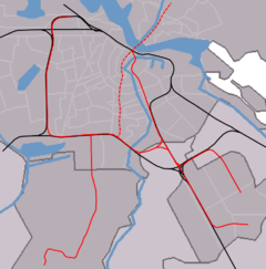 De Vlugtlaan Location within metro van Amsterdam | |||||||||||
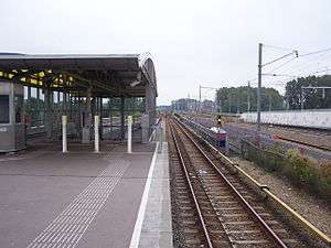
De Vlugtlaan is a metro station on line 50 in Amsterdam, the Netherlands. Between 1986 and 2000, Amsterdam De Vlugtlaan railway station was in use on the railway running parallel next to the metro line.
History
The railway station opened on 1 June 1986 together with the western section of the Amsterdam Ring railway. It was situated between Amsterdam Lelylaan and Amsterdam Sloterdijk. The station was originally to be called Burgemeester De Vlugtlaan, named after Willem de Vlugt, mayor (burgemeester) of Amsterdam from 1921 to 1941. However, the Burgemeester was eventually dropped. The station was designed by Rob Steenhuis, architect of over 10 stations in the Netherlands in the period 1982-1996. The station was only served by local trains from Hoofdorp and Schiphol to Lelystad or Amersfoort Schothorst.
On 1 June 1997, metro line 50 opened next to the station and the metro stop was called De Vlugtlaan. The original construction of the railway station needed to be amended by demolishing one of the stairs leading to the railway platforms and half of the station hall.
The railway station had to close in May 2000 due to the construction of the Hemboog.