Amphitheater Lake Trail
| Amphitheater Lake Trail | |
|---|---|
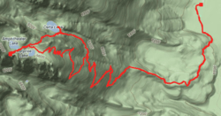 Map of the trail | |
| Length | 5 mi (8 km) |
| Location | Teton Range |
| Trailheads | Lupine Meadows |
| Use | Hiking |
| Elevation | |
| Elevation change | Approximate gain of 3,150 ft (960 m) |
| Highest point | Amphitheater Lake, 9,698 ft (2,956 m) |
| Lowest point | Lupine Meadows, 6,732 ft (2,052 m) |
| Hiking details | |
| Season | Summer to Fall |
| Sights | Teton Range |
| Hazards | Severe weather |
The Amphitheater Lake Trail is a 5-mile (8.0 km) long hiking trail in Grand Teton National Park in the U.S. state of Wyoming.[1] The trailhead is at the Lupine Meadows parking area and climbs steeply more than 3,000 feet (910 m) in just over 5 miles (8.0 km) to Amphitheater Lake.[2] At the 2-mile (3.2 km) point, the trail forks and the Garnet Canyon Trail heads south and then west into Garnet Canyon.[3] Shortly before arriving at Amphitheater Lake, hikers pass Surprise Lake where there is a backcountry camping site available if one obtains a free permit.[4] Amphitheater Lake is southwest of Disappointment Peak. Coordinates: 43°43′39″N 110°45′58″W / 43.7274318°N 110.7660460°W[5]
See also
References
- ↑ "Lupine Meadows Trailhead" (pdf). National Park Service. Retrieved 2012-05-19.
- ↑ "Day Hikes" (pdf). National Park Service. February 2012. Retrieved 2012-05-11.
- ↑ Grand Teton, WY (Map). Topoquest (USGS Quads). Retrieved 2012-05-11.
- ↑ "Backcountry Camping" (pdf). National Park Service. October 2006. Retrieved 2012-05-11.
- ↑ "Amphitheater Lake Trail". Geographic Names Information System. United States Geological Survey. Retrieved 2012-05-11.
This article is issued from
Wikipedia.
The text is licensed under Creative Commons - Attribution - Sharealike.
Additional terms may apply for the media files.