Amper
| Amper | |
|---|---|
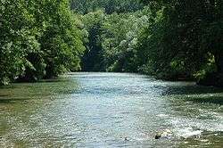 The Amper south of Fürstenfeldbruck | |
| Country | Germany |
| Location | Bavaria, Germany |
| Physical characteristics | |
| Main source | Northern Limestone Alps |
| River mouth |
Isar 48°30′1″N 11°57′24″E / 48.50028°N 11.95667°ECoordinates: 48°30′1″N 11°57′24″E / 48.50028°N 11.95667°E |
| Length | 190 km (120 mi) |
| Discharge |
|
| Basin features | |
| Progression | Isar→ Danube→ Black Sea |
| Basin size | 3,248 km2 (1,254 sq mi) [1] |
The Amper, called the Ammer upstream of the Ammersee, through which it runs, is the largest tributary of the Isar in southern Bavaria, Germany. It flows generally north-eastward, reaching the Isar in Moosburg, about 190 kilometres (120 mi) from its source in the Ammergau Alps, with a flow of 45 m³/s. Including its tributary, Linder, it is 209.5 km (130.2 mi) long.[1] Major tributaries are the Glonn, which springs near Augsburg; the Würm, which is the outflow of Lake Starnberg; and the Maisach.
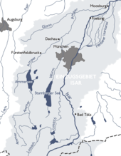
The Ammer starts just south of the village of Oberammergau. Riverside cities include Fürstenfeldbruck, Dachau and Moosburg.
References
- 1 2 Complete table of the Bavarian Waterbody Register by the Bavarian State Office for the Environment (xls, 10.3 MB)
External links
- Official website (in German)
This article is issued from
Wikipedia.
The text is licensed under Creative Commons - Attribution - Sharealike.
Additional terms may apply for the media files.