Amicalola, Georgia
| Amicalola | |
|---|---|
| Unincorporated community | |
 Amicalola Location within the state of Georgia | |
| Coordinates: 34°33′17″N 84°15′9″W / 34.55472°N 84.25250°WCoordinates: 34°33′17″N 84°15′9″W / 34.55472°N 84.25250°W | |
| Country | United States |
| State | Georgia |
| County | Dawson |
| Elevation | 1,755 ft (535 m) |
| Time zone | UTC-5 (Eastern (EST)) |
| • Summer (DST) | UTC-4 (EDT) |
| GNIS feature ID | 354300[1] |
Amicalola is an unincorporated community located in Dawson County, Georgia, United States. It was named for the falls and nearby Amcalola Mountain. Amicalola means tumbling water in the Cherokee language; the Cherokee people lived throughout Georgia and southeastern Tennessee before Indian Removal.
A post office called Amicalola was established in 1846, and remained in operation until 1923.[2] The community takes its name from nearby Amicalola Creek.[3]
References
- ↑ "Amicalola, Georgia". Geographic Names Information System. United States Geological Survey.
- ↑ "County". Jim Forte Postal History. Retrieved 6 September 2017.
- ↑ Krakow, Kenneth K. (1975). Georgia Place-Names: Their History and Origins (PDF). Macon, GA: Winship Press. p. 5. ISBN 0-915430-00-2.
Municipalities and communities of Dawson County, Georgia, United States | ||
|---|---|---|
| City | 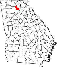 | |
| Unincorporated communities | ||
| Footnotes | ‡This populated place also has portions in an adjacent county or counties | |
This article is issued from
Wikipedia.
The text is licensed under Creative Commons - Attribution - Sharealike.
Additional terms may apply for the media files.