Amfreville, Manche
| Amfreville | |
|---|---|
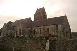 Church of Saint-Martin | |
 Amfreville Location within Normandy region  Amfreville | |
| Coordinates: 49°24′38″N 1°23′29″W / 49.4106°N 1.3914°WCoordinates: 49°24′38″N 1°23′29″W / 49.4106°N 1.3914°W | |
| Country | France |
| Region | Normandy |
| Department | Manche |
| Arrondissement | Cherbourg |
| Canton | Carentan |
| Intercommunality | Baie du Cotentin |
| Government | |
| • Mayor (-) | - |
| Area1 | 10.10 km2 (3.90 sq mi) |
| Population (2013)2 | 288 |
| • Density | 29/km2 (74/sq mi) |
| Time zone | UTC+1 (CET) |
| • Summer (DST) | UTC+2 (CEST) |
| INSEE/Postal code | 50005 /50480 |
| Elevation |
1–31 m (3.3–101.7 ft) (avg. 14 m or 46 ft) |
|
1 French Land Register data, which excludes lakes, ponds, glaciers > 1 km2 (0.386 sq mi or 247 acres) and river estuaries. 2 Population without double counting: residents of multiple communes (e.g., students and military personnel) only counted once. | |
Amfreville is a former commune in the Manche department in the Normandy region in northwestern France. On 1 January 2016, it was merged into the commune of Picauville.[1]
Population
| Historical population | ||
|---|---|---|
| Year | Pop. | ±% |
| 1821 | 938 | — |
| 1831 | 820 | −12.6% |
| 1836 | 805 | −1.8% |
| 1841 | 848 | +5.3% |
| 1846 | 830 | −2.1% |
| 1851 | 793 | −4.5% |
| 1856 | 741 | −6.6% |
| 1861 | 759 | +2.4% |
| 1866 | 786 | +3.6% |
| 1872 | 726 | −7.6% |
| 1876 | 786 | +8.3% |
| 1881 | 771 | −1.9% |
| 1886 | 717 | −7.0% |
| 1891 | 683 | −4.7% |
| 1896 | 642 | −6.0% |
| 1901 | 614 | −4.4% |
| 1906 | 626 | +2.0% |
| 1911 | 610 | −2.6% |
| 1921 | 571 | −6.4% |
| 1926 | 540 | −5.4% |
| 1931 | 523 | −3.1% |
| 1936 | 491 | −6.1% |
| 1946 | 459 | −6.5% |
| 1954 | 430 | −6.3% |
| 1962 | 414 | −3.7% |
| 1968 | 369 | −10.9% |
| 1975 | 333 | −9.8% |
| 1982 | 312 | −6.3% |
| 1990 | 295 | −5.4% |
| 1999 | 290 | −1.7% |
| 2009 | 295 | +1.7% |
See also
References
- ↑ Arrêté préfectoral 23 December 2015 (in French)
| Wikimedia Commons has media related to Amfreville (Manche). |
This article is issued from
Wikipedia.
The text is licensed under Creative Commons - Attribution - Sharealike.
Additional terms may apply for the media files.