Ambrose Channel
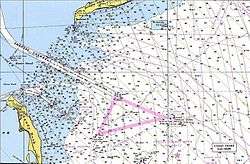
Ambrose Channel is the only shipping channel in and out of the Port of New York and New Jersey. The channel is considered to be part of Lower New York Bay and is located several miles off the coasts of Sandy Hook, New Jersey, and Breezy Point, New York. Ambrose Channel terminates at Ambrose Anchorage, just south of the Verrazano Narrows Bridge, the gateway to New York Harbor, where it becomes known as the Anchorage Channel.[1] It is named for John Wolfe Ambrose
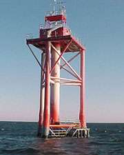
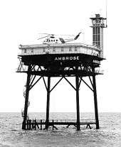
The entrance to the channel was marked by Ambrose Light which doubled as a staging area for pilot boats, most notably the Sandy Hook Pilots. Prior to the construction of the light tower in 1967 the channel was marked by the Ambrose Lightship, one of a class of lightships operated and maintained by the United States Coast Guard for the express purpose of marking main shipping channels for major ports. After several allisions, the light tower was redesigned and relocated in 1999, and finally decommissioned and removed in 2008.
Once inside the Narrows Ambrose becomes the Anchorage Channel which splits to channels to marine terminals.[2] Connecting channels are the Bay Ridge, the Red Hook, the Buttermilk, the Claremont, the Port Jersey, the Kill Van Kull, the Newark Bay, the Port Newark, the Elizabeth, and the Arthur Kill. Anchorages are known as Stapleton, Bay Ridge and Gravesend.[3]
See also
References
Notes
- ↑ USACE
- ↑ "Ambrose Federal Navigation Channel". US Army Corps of Engineers.
- ↑ "Intent To Prepare a Draft Environmental Impact Statement (DEIS) for the New York and New Jersey Harbor Navigation Study: Feasibility Phase". Federal Register Volume 63. Government Printing Office. March 24, 1998. Retrieved 2014-08-31.
Further reading
- "Historic Light Station Information and Photography: New York". United States Coast Guard Historian's Office.
- National Data Buoy Center - Station ALSN6 - Ambrose Light, NY
- New York Harbor Approaches, NOAA Chart 12326 online.
External links
- Sandy Hook Pilots
- South Street Seaport Museum - Current location of the Ambrose Lightship
Coordinates: 40°31′06″N 73°59′25″W / 40.5184398°N 73.9904166°W