Amatzia, Israel
| Amatzia אֲמַצְיָה | |
|---|---|
| Hebrew transcription(s) | |
| • standard | Amatzya |
| • official | Amazya |
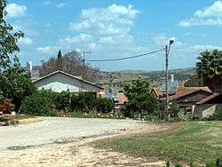 A house in Amatzia built in the 1950s | |
 Amatzia | |
| Coordinates: 31°31′57.35″N 34°54′48.96″E / 31.5325972°N 34.9136000°ECoordinates: 31°31′57.35″N 34°54′48.96″E / 31.5325972°N 34.9136000°E | |
| District | Southern |
| Council | Lakhish |
| Affiliation | Mishkei Herut Beitar |
| Founded | 1955 |
| Population (2017) | 465[1] |
| Name meaning | Named for Amaziah of Judah |
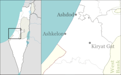
Amatzia (Hebrew: אֲמַצְיָה) is a moshav in south-central Israel. Located around 8 km southeast of Lakhish, it falls under the jurisdiction of Lakhish Regional Council. The population is a mix of religious and secular Israelis, and was 465 in 2017.[1]
History
The moshav was founded in 1955, and is located on the land of the depopulated Palestinian village of Al-Dawayima, the scene of the 1948 Al-Dawayima massacre.[2]
It was named for King Amaziah of Judah, who, according to the Book of Kings, was killed in the Lakhish region. In the past the community was a moshav shitufi but it has undergone a process of privatization and abandoned its communal nature.
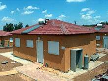
In 2006, temporary housing was built in the area of the moshav to absorb evacuees from Katif who lived in Gush Katif but were evacuated under Israel's unilateral disengagement plan.
References
- 1 2 "List of localities, in Alphabetical order" (PDF). Israel Central Bureau of Statistics. Retrieved August 26, 2018.
- ↑ Khalidi, Walid (1992). All That Remains: The Palestinian Villages Occupied and Depopulated by Israel in 1948. Washington D.C.: Institute for Palestine Studies. p. 215. ISBN 0-88728-224-5.
External links
| Wikimedia Commons has media related to Amatzia. |
- Amatzia in Lakhish Regional Council web site (in Hebrew).
- Map of Amatzia (in Hebrew).
- Aerial photograph of Amatzia.