Allison, New South Wales
Napier County

Coolah Black Stump
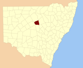
Allison Parish, New South Wales is a rural locality of Warrumbungle Shire Council and a civil parish of Napier County[1] a county of central western New South Wales.[2]
The civil parish is located outside of Coolah, New South Wales, and by some accounts is the location of the proverbial Black Stump. During colonial times the Coolburragundy River was a boundary of the Nineteen Counties in the colony of New South Wales, Australia. Settlers were permitted to take up land only within the 19 counties due to the dangers in the wilderness. The stump in Allison parish being on the other side of the river from the civilized areas was therefore a colloquial marker for the beginning of the outback.
References
- ↑ Robert McLean, The New atlas of Australia : the complete work containing over one hundred maps and full descriptive geography of New South Wales, Victoria, Queensland, South Australia and Western Australia, together with numerous illustrations and copious indices (Sydney :J. Sands, [1886) Map 14.
- ↑ "Napier County". Geographical Names Register (GNR) of NSW. Geographical Names Board of New South Wales.
This article is issued from
Wikipedia.
The text is licensed under Creative Commons - Attribution - Sharealike.
Additional terms may apply for the media files.