All Saints Church, Wyke Regis
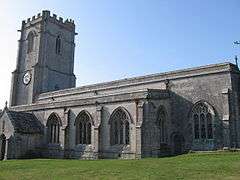
All Saints Church is an active Church of England church of 15th-century origin in Wyke Regis, Weymouth, Dorset, England. Built largely of Portland stone, the Royal Commission on the Historical Monuments of England have described the church as a "remarkably consistent and unchanged 15th-century design". It has been Grade I Listed since 1953.[1]
History
The present All Saints Church dates to the mid-15th-century, however a church has been recorded on the same site as early as 1172.[2] The present building was completed in 1455 and re-consecrated on 19 October that year.[3][1] All Saints was the original parish church of Weymouth until the 19th-century, when other churches were built to meet the growing population, including Holy Trinity Church, overlooking Weymouth Town Bridge, St Paul's Church in Westham and St Edmund's Church in Lanehouse.[4]
Overlooking the Isle of Portland and Chesil Beach, the tower of the church was a prominent landmark for vessels during the age of sail.[5] Within the cemetery are the unmarked graves of around eighty who died on-board the Earl of Abergavenny, including the captain John Wordsworth, brother of the poet William Wordsworth. The ship sank in Weymouth Bay in 1805 after striking the Shambles Sandbank off of the Isle of Portland. Bodies recovered from the merchant vessel Alexander, wrecked in 1815, are also buried in the churchyard.[6] Facing Wyke Road from the modern cemetery opposite the church is the Wyke Regis War Memorial, erected in 1919.
References
- 1 2 "CHURCH OF ALL SAINTS, Weymouth and Portland - 1096743". Historic England. 1953-12-12. Retrieved 2017-10-30.
- ↑ "Weymouth,Dorset,England - Wyke Regis - Wyke Square & Village". Weymouth-dorset.co.uk. Retrieved 2017-10-30.
- ↑ "Church Virtual Tour". Hepburn.uk.net. Retrieved 2017-10-30.
- ↑ "All Saints Church". The Parish of Wyke Regis. Retrieved 2017-10-30.
- ↑ "Wyke Regis Parish Records, Dorset". Opcdorset.org. 2013-02-19. Retrieved 2017-10-30.
- ↑ "Ships Monthly - Google Books". Books.google.co.uk. 2008-01-22. Retrieved 2017-10-30.