Alkabo, North Dakota
| Alkabo, North Dakota | |
|---|---|
| Unincorporated community | |
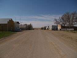 A street in Alkabo | |
 Alkabo  Alkabo | |
| Coordinates: 48°51′46″N 103°53′25″W / 48.86278°N 103.89028°WCoordinates: 48°51′46″N 103°53′25″W / 48.86278°N 103.89028°W | |
| Country | United States |
| State | North Dakota |
| County | Divide |
| Elevation | 2,188 ft (667 m) |
| Time zone | UTC-6 (Central (CST)) |
| • Summer (DST) | UTC-5 (CDT) |
| Area code(s) | 701 |
| GNIS feature ID | 1027671[1] |
Alkabo is an unincorporated community in Divide County, North Dakota, United States. Alkabo is located on the Dakota, Missouri Valley and Western Railroad 6 miles (9.7 km) west-southwest of Fortuna.[2] The Alkabo School, which is listed on the National Register of Historic Places, is located in Alkabo.[3]
The name is a blend of alkali and gumbo, two types of soil found in the area.[4]
See also
References
- ↑ "Alkabo". Geographic Names Information System. United States Geological Survey.
- ↑ Divide County, North Dakota General Highway Map (PDF) (Map). North Dakota Department of Transportation. 2003. Retrieved July 12, 2012.
- ↑ "National Register Information System". National Register of Historic Places. National Park Service. Retrieved July 12, 2012.
- ↑ Williams, Mary Ann Barnes (1966). Origins of North Dakota Place Names. Bismarck, ND: Bismarck Tribune. p. 91.
External links
- "Alkabo, ND". Ghosts of North Dakota. Retrieved 2012-12-27.
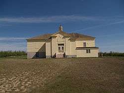
The Alkabo School
Municipalities and communities of Divide County, North Dakota, United States | ||
|---|---|---|
| Cities | 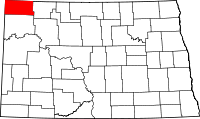 | |
| Townships |
| |
| Unincorporated communities | ||
| Indian reservation | ||
| Footnotes | ‡This populated place also has portions in an adjacent county or counties | |
This article is issued from
Wikipedia.
The text is licensed under Creative Commons - Attribution - Sharealike.
Additional terms may apply for the media files.