Aldenham Reservoir
| Aldenham Reservoir | |
|---|---|
 | |
| Location | Hertfordshire |
| Coordinates | 51°38′45″N 0°18′40″W / 51.64583°N 0.31111°WCoordinates: 51°38′45″N 0°18′40″W / 51.64583°N 0.31111°W |
| Type | reservoir |
| Basin countries | United Kingdom |
| Surface area | 55 acres (220,000 m2) |

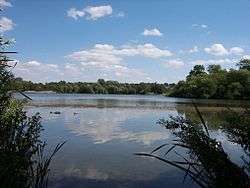
Aldenham Reservoir is situated in the parish of Elstree and Borehamwood in Hertfordshire, England, about one mile (1.6 km) to the west of the village of Elstree.
Originally, it was 65 acres (260,000 m2) in extent, but following repairs to the dam its surface area is now 55 acres (220,000 m2). It was built between 1795 and 1797 by the Grand Junction Canal Company, to control the water levels in the River Colne following the construction of the Grand Junction Canal, and was hand dug by French prisoners of war.[1][2]
It is the source of the stream, Tykes Water, that runs north through Radlett. Nearby is the much larger Hilfield Park Reservoir, a nature reserve owned by Affinity Water.
It now forms the centrepiece of the Aldenham Country Park and is used for recreational purposes, including fishing and sailing.
References