Alcantarilla Dam
| Alcantarilla Dam | |
|---|---|
| Location | Toledo province, Castilla-La Mancha, Spain |
| Coordinates | 39°39′36″N 4°3′28″W / 39.66000°N 4.05778°WCoordinates: 39°39′36″N 4°3′28″W / 39.66000°N 4.05778°W |
| Opening date | 1st century |
| Dam and spillways | |
| Impounds | Guajaraz (Tajo basin)[1] |
| Height | 20 m (66 ft) |
| Length | >800 m (2,600 ft) |
| Width (base) | 4 m (13 ft)? |
The Alcantarilla Dam is a ruined Roman gravity dam in Mazarambroz, Toledo province, Castilla-La Mancha, Spain, dating to the 1st century AD. The toponym "Alcantarilla" means conduit and is of Arabic origin:[2] the Latin name is unknown.[1]
The dam and reservoir were part of the water supply system of the city of Toletum (Toledo). The structure appears to have been similar to the surviving Proserpina Dam near Merida, an earth dam with a stone retaining wall.[3]
Conservation
The structure has been in ruins for a long time. There has been speculation that it was not strong enough to cope with a large volume of water. It was possibly breached in the Roman era.[3]
The remains of Toledo´s Roman water supply system are partly protected by a heritage designation (Bien de Interés Cultural).[4]
See also
Notes
- 1 2 Spann, P. "Places: 268784 (Untitled)". Pleiades. Retrieved 2018-05-17.
- ↑ It is the diminutive of "alcántara" from the Arabic word al-QanTarah (القنطرة) meaning "the bridge".
- 1 2 Arenillas & Castillo 2003
- ↑ "Restos del acueducto" [Remains of the aqueduct] (in Spanish). Retrieved 2018-05-29.
References
- Arenillas, Miguel; Castillo, Juan C. (2003), "Dams from the Roman Era in Spain. Analysis of Design Forms (with Appendix)", 1st International Congress on Construction History [20th–24th January], Madrid
Further reading
- Hodge, A. Trevor (1992), Roman Aqueducts & Water Supply, London: Duckworth, pp. 87–89, ISBN 0-7156-2194-7
- Schnitter, Niklaus (1978), "Römische Talsperren", Antike Welt, 8 (2): 25–32 (29)
- Smith, Norman (1971), A History of Dams, London: Peter Davies, p. 48, ISBN 0-432-15090-0
| Portugal | 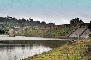 | |
|---|---|---|
| Spain | ||
| Syria | ||
| Other countries | ||