Albula Pass
| Albula Pass | |
|---|---|
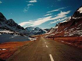 Albula Pass road | |
| Elevation | 2,315 m (7,595 ft) |
| Traversed by | Road |
| Location | Graubünden, Switzerland |
| Range | Alps |
| Coordinates | 46°35′N 09°53′E / 46.583°N 9.883°ECoordinates: 46°35′N 09°53′E / 46.583°N 9.883°E |
 Albula Pass Location in Switzerland | |

Albula Pass (Romansh: Pass d'Alvra[1] or ![]()
East of the pass, on the Engadin side, is a lake named Albulasee (2,294 m) which is 4.2 ha large.[3]
See also
References
- ↑ Swisstopo maps, official maps of Switzerland by the Swiss government
- ↑ "Pass da l'Alvra in the Pledari Grond dictionary". Archived from the original on 2011-07-07. Retrieved 2008-07-24.
- ↑ Area retrieved from Google Earth (December 2014)
External links
| Wikimedia Commons has media related to Albula Pass. |
| Wikisource has the text of the 1911 Encyclopædia Britannica article Albula Pass. |
- Profile on climbbybike.com
- Albula Pass in Romansh, German, French and Italian in the online Historical Dictionary of Switzerland.
- http://www.alpentourer.com/alpine_passes/switzerland/albulapass/albulapass.html
This article is issued from
Wikipedia.
The text is licensed under Creative Commons - Attribution - Sharealike.
Additional terms may apply for the media files.