Albert-Eden Local Board
| Local Board of Auckland Council | |
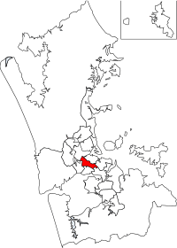 Location of Albert-Eden in Auckland | |
| Formation | 2010 |
|---|---|
| Coordinates | 36°52′22″S 174°45′07″E / 36.872813°S 174.751810°ECoordinates: 36°52′22″S 174°45′07″E / 36.872813°S 174.751810°E |
Chair | Peter Haynes (CV) |
Deputy Chair | Glenda Fryer (CV) |
Political groups | |
Ward | Albert-Eden-Roskill |
Budget | NZ$32,925,000 |
The Albert-Eden Local Board is one of the 21 local boards of the Auckland Council, and is one of the two boards overseen by the council's Albert-Eden-Roskill ward councillors.
The Albert-Eden board, named after the two volcanic cones in the board area: Mount Albert and Mount Eden, covers the suburbs of Balmoral, Epsom, Greenlane, Kingsland, Morningside, Mount Albert, Mount Eden, Owairaka, Point Chevalier, Sandringham, and Waterview.[1] The total population residing in the Albert-Eden Local Board area, as of the June 2017 was 109200.[2]
The board is governed by eight board members elected from two subdivisions: four from the Owairaka subdivision (western half of the board area), and four from the Maungawhau subdivision (eastern half).[1] The first board members were elected with the nationwide local elections on Saturday 9 October 2010; the local board's second election closed on 12 October 2013.
Population
As of 2013, Albert-Eden had a total population of 94,695, with an average age of 34. It had a Māori population of 6,108, with an average age of 27.3. The area had a total of 34,134 dwellings. The population was 63.2% European, 6.8% Māori, 7.8% Pacific and 28.2% Asian. 2.1% of the population was Middle Eastern, Latin American and African, and 1.2% were part of other ethnic groups. 38.4% percent of the population was born overseas.[3]
The median income of Albert-Eden residents was $32,800, and 90.2% of the population had formal qualifications. 55.5% of households owned their own home, and 86.1% had access to the internet. The median rent was $370 per household.[3]
Economy
As of 2013, 21% of people were employed in healthcare and social assistance, making it the largest source of employment in the local board area. 13% of people were employed in education and training, 13% were in professional, scientific and technical service roles, and 12% were in the retail trade. 8% of Albert-Eden residents worked in accommodation and food services.[3]
References
- 1 2 "Albert-Eden local board and subdivisions map" (PDF). Retrieved 2010-07-23.
- ↑ "Subnational Population Estimates: At 30 June 2017 (provisional)". Statistics New Zealand. 24 October 2017. Retrieved 24 October 2017. For urban areas, "Subnational population estimates (UA, AU), by age and sex, at 30 June 1996, 2001, 2006-16 (2017 boundary)". Statistics New Zealand. 24 October 2017. Retrieved 24 October 2017.
- 1 2 3 "QuickStats about Albert-Eden Local Board Area" (PDF). New Zealand Census. Statistics New Zealand. Retrieved 10 May 2015.