Alay Mountains
| Alay Mountains | |
|---|---|
|
Kyrgyz: Алай тоо кыркасы | |
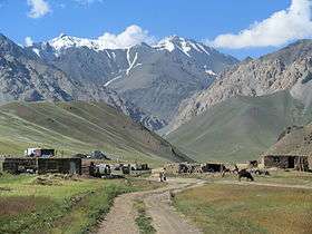 Alai Mountains from Jiptik Valley | |
| Highest point | |
| Elevation | 5,544 m (18,189 ft) |
| Dimensions | |
| Length | 350 km (220 mi) W-S [1] |
| Width | 20 km (12 mi) N-S [1] |
| Geography | |
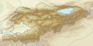 Location of the Alay Mountains | |
| Countries | Kyrgyzstan and Tajikistan |
| Regions | Batken Region and Osh Region |
| Range coordinates | 39°40′N 72°0′E / 39.667°N 72.000°ECoordinates: 39°40′N 72°0′E / 39.667°N 72.000°E |
The Alay or Alai Mountains (Kyrgyz: Алай тоо кыркасы; Russian: Алайский хребет) constitute a mountain range that extends from the Tien Shan mountain range in Kyrgyzstan west into Tajikistan. It is part of the Pamir-Alai mountain system. The range runs approximately east to west.[2] Its highest summit is Pik Tandykul (Russian: пик Тандыкуль), 5544 m.[3] The southern slopes of the range drain into the Vakhsh River, a tributary of the Amu Darya. The streams that drain the northern slopes of the range are tributaries of the Syr Darya, and empty into the Fergana Valley to the north of the range.
Some sources seem to use the term for the whole southern curve of the Tian Shan corresponding to the southern border of Kyrgyzstan.
See also
References
- 1 2 Атлас Кыргызской Республики [Atlas of Kyrgyz Republic] (in Russian). Bishkek: Academy of Sciences of Kyrgyz SSR. 1987. p. 156.
- ↑ M. Shahgedanova, The physical geography of northern Eurasia, Oxford University Press, 2003, ISBN 978-0-19-823384-8, chapter 16
- ↑ Soviet Union military map 1:500.000 J-42-Б
| Authority control |
|---|
This article is issued from
Wikipedia.
The text is licensed under Creative Commons - Attribution - Sharealike.
Additional terms may apply for the media files.