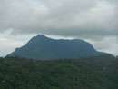
Alagalla Mountain Range
| Alagalla Mountain Range | |
|---|---|
| Tuber Rock Mountain Range | |
 | |
| Highest point | |
| Elevation | 1,140 m (3,740 ft) |
| Coordinates | 7°15′12″N 80°26′47″E / 7.25333°N 80.44639°ECoordinates: 7°15′12″N 80°26′47″E / 7.25333°N 80.44639°E |
| Geography | |
 Alagalla Mountain Range | |
Alagalla (Sinhala:අලගල්ල, literal translation: Tuber rock) Mountain Range is situated at the boundaries of the Central and Sabaragamuwa Provinces in Sri Lanka. Along with the surrounding Bathalegala (Sinhala:බතලේගල) aka Bible Rock, Uthuwankanda (Sinhala:උතුවන්කන්ද), Devanagala (Sinhala: දෙවනගල), Ambuluwawa (Sinhala:අම්බුළුවාව), Knuckles Mountain Range and Hanthana (Sinhala:හන්තාන) Mountain Range, Alagalla mountain has served as a natural defense location for nearly five centuries (1505–1948) against the Portuguese, Dutch and English invasions aimed at the Kandyan Kingdom.
Historical importance
Most of the battles to invade the Kandyan Kingdom took place at Balana (Literal translation: Viewing Point), with the Kandyan monarchs emerging victorious aided by the impenetrable mountain formations. The famous Balana fort which functioned as a strategic rock fortress and an outpost to Kandyan kingdom was built between Kadugannawa pass[1] and Alagalla Mountain Range.
Meangalla Pass and Meeyangala tunnel
The railway lines to upcountry were established by the English once the Kandyan Kingdom was absorbed into the British Empire in 1815. However, extending the already working Colombo-Ambepussa (Sinhala: අඹේපුස්ස) mainline[2] [3]across the Alagalla mountain to Kandy proved to be extremely challenging as it had to be navigated around a waterfall, Meeyan Ella (Sinhala: මීයන් ඇල්ල) about 100 ft high falling directly on the planned route and across a steeply inclined solid rock of more than 1000 ft thick.
Initially, the railway track was constructed by gouging artificial grooves on the rock at the top of the waterfall to "split" the waterfall into two and fall away from the rail route[4]. The tracks were then set up around the inclined rock[5] and this was called the Meangalla (Sinhala:මීන්ගල්ල) pass. However, this railway route was found to be dangerous, especially in the rainy season as heavy rains caused the swollen waterfall and slip rocks to damage the trains and the rail tracks[6][7].
This resulted in a more robust and safe rerouting via drilling through the solid rock[8]. The Meeyangalla (Sinhala:මීයන්ගල්ල) tunnel, thus constructed and numbered as tunnel 5A, became the sixth tunnel in the Colombo-Kandy railway line and also the second longest railway tunnel in Sri Lanka at 423 m (approximately 1387 ft) long[9][10].
Hiking through the Alagalla Mountains

Alagalla mountains can be reached by taking either the Colombo-Kandy line to Ihalakotte railway station, or by taking the Kandy- Poththapitiya bus from Pilimathalawa to Poththapitya junction.
If following the Ihalakotte route, trekking can be started at Ihalakotte railway station through the Ihalakotte village. The 6 m (approximately 20 ft) high Dekinda ella (Sinhala:දෙකිඳ ඇල්ල) waterfall, served by the Alagalla forest reserve,[11] can also be viewed slightly off-route. Alternatively, a slightly longer trekking path via Poththapitiya can be reached by taking the Kandy- Poththapitiya bus route to Poththapitiya junction from Pilimathalawa. In both routes, the support of a local guide is strongly encouraged.
The summit of the Alagalla mountain Range is a platform to witness the view of the other surrounding mountains, including Bathalegala (Sinhala:බතලේගල) aka Bible Rock, Devanagala (Sinhala:දෙවනගල), Ambuluwawa (Sinhala:අම්බුළුවාව), Knuckles Mountain Range and Hanthana (Sinhala:හන්තාන) Mountain Range.
See also
References
- ↑ "Kadugannawa the gateway to Kanda Uda Rata | FT Online". www.ft.lk. Retrieved 2018-08-11.
- ↑ "Online edition of Daily News - Features". archives.dailynews.lk. Retrieved 2018-08-11.
- ↑ "Through tunnels and rocks on the main line". www.sundaytimes.lk. Retrieved 2018-08-11.
- ↑ "අලට කන්න බැරි අලගල්ලේ කන්ද". දිනමිණ (in Sinhala). Retrieved 2018-08-11.
- ↑ "Meeyan Ella Incline – මීයන් ඇල්ල දුර්ග මාර්ගය". ලංකා දුම්රිය (in Sinhala). 2014-07-30. Retrieved 2018-08-11.
- ↑ "මොරියාටි ගේ ඉසව්ව". moriyati7.blogspot.com. Retrieved 2018-08-11.
- ↑ "වළගොඩ ගමේ ආච්චිලා - ඔයට බැස හාල් ගැරූ මීයන්ඇල්ල දුම්රිය අනතුරේ කතාව". සිළුමිණ (in Sinhala). 2018-07-20. Retrieved 2018-08-12. soft hyphen character in
|title=at position 3 (help) - ↑ "Focus | Sundayobserver.lk - Sri Lanka". 2016-03-03. Retrieved 2018-08-11.
- ↑ "පරිශීලක සාකච්ඡාව:Ranshan Fernando", විකිපීඩියා, නිදහස් විශ්වකෝෂය (in Sinhala), 2015-11-24, retrieved 2018-08-11
- ↑ "සඟරජලෙන පසු කර මීයන් ඇල්ල බිංගෙය සොයා". සිළුමිණ (in Sinhala). 2018-07-13. Retrieved 2018-08-11. soft hyphen character in
|title=at position 3 (help) - ↑ "Dekinda Ella Falls – දෙකින්ද ඇල්ල". Amazing Lanka. Retrieved 1 September 2016.