Akseløya
 | |
 Svalbard | |
| Location |
Akseløya Svalbard Norway |
|---|---|
| Coordinates | 77°44′49.3″N 14°34′12.6″E / 77.747028°N 14.570167°E |
| Construction | metal skeletal tower |
| Tower shape | square piramydal skeletal tower with enclosed upper part |
| Markings / pattern | black tower, red upper part |
| Height | 7 metres (23 ft) |
| Focal height | 15 metres (49 ft) |
| Light source | solar power |
| Range | 8 nautical miles (15 km; 9.2 mi) |
| Characteristic | Fl W 5s. |
| Admiralty number | L4304 |
| NGA number | 17820 |
| ARLHS number | SVA-006 |
| Norway number | NF-9958[1][2] |
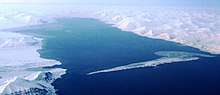
Akseløya (English: Axel Island) is a long, narrow island (about 8.5 km long and 1 km wide) at the mouth of Van Mijenfjorden, separating Van Mijenfjorden from Bellsund. It is separated from the mainland by Akselsundet to the north, and another narrow strait to the south. The islands are named after the schooner Aksel Thordsen, which was chartered by Adolf Erik Nordenskiöld for an expedition to Svalbard in 1864.
See also
References
- ↑ Svalbard The Lighthouse Directory. University of North Carolina at Chapel Hill. Retrieved 6 September 2016
- ↑ List of Lights, Buoys and Fog Signals. Atlantic Coast Norway and Arctic Sea. Retrieved 6 September 2016
- Conway, W. M. 1906. No Man’s Land: A History of Spitsbergen from Its Discovery in 1596 to the Beginning of the Scientific Exploration of the Country. Cambridge: At the University Press.
- Norwegian Polar Institute Place Names of Svalbard Database
External links
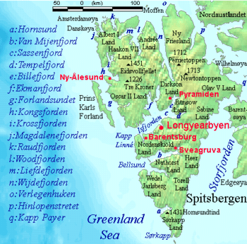
Akseløya can be seen between Bellsund and Van Mijenfjorden, the latter labeled as b.
Coordinates: 77°42.8′N 14°41.5′E / 77.7133°N 14.6917°E
This article is issued from
Wikipedia.
The text is licensed under Creative Commons - Attribution - Sharealike.
Additional terms may apply for the media files.