Airdrie Aerodrome
| Airdrie Aerodrome | |||||||||||
|---|---|---|---|---|---|---|---|---|---|---|---|
 | |||||||||||
| Summary | |||||||||||
| Airport type | Private | ||||||||||
| Operator | Airdrie Airpark Ltd. | ||||||||||
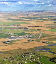
| Location | Airdrie, Alberta | ||||||||||
| Time zone | MST (UTC−07:00) | ||||||||||
| • Summer (DST) | MDT (UTC−06:00) | ||||||||||
| Elevation AMSL | 3,653 ft / 1,113 m | ||||||||||
| Coordinates | 51°15′50″N 113°56′04″W / 51.26389°N 113.93444°WCoordinates: 51°15′50″N 113°56′04″W / 51.26389°N 113.93444°W | ||||||||||
| Map | |||||||||||
 CEF4 Location in Alberta | |||||||||||
| Runways | |||||||||||
| |||||||||||
|
Source: Canada Flight Supplement[1] | |||||||||||
Airdrie Aerodrome (TC LID: CEF4) is a registered aerodrome located 2.6 nautical miles (4.8 km; 3.0 mi) southeast of Airdrie, Alberta, Canada.
History
The aerodrome was used as the primary relief landing field for No. 3 Service Flying Training School (SFTS)during World War II. No. 3 SFTS was based out of RCAF Station Lincoln Park in Calgary.
Aerodrome information
In approximately 1942 the aerodrome was listed at 51°16′N 113°56′W / 51.267°N 113.933°W with a Var. 24 degrees E and elevation of 3650'. The aerodrome was listed with three runways as follows: [2]
| Runway Name | Length | Width | Surface |
|---|---|---|---|
| 16/34 | 2975' | 100' | Hard Surface |
| 10/28 | 2975' | 100' | Hard Surface |
| 4/22 | 2975' | 2975' | Hard Surface |
Airdrie Regional Airshow
The Airdrie Regional Airshow was held here every 2 years. Displays such as the Snowbirds, Viper West and CF-18 hornet demo team were shown in the past.
Due to the opening of runway 17L/35R at Calgary International Airport in 2014, the airshow was relocated to the Calgary/Springbank Airport becoming Wings over Springbank.
See also
References
- ↑ Canada Flight Supplement. Effective 0901Z 19 July 2018 to 0901Z 13 September 2018.
- ↑ Staff writer (c. 1942). Pilots Handbook of Aerodromes and Seaplane Bases Vol. 2. Royal Canadian Air Force. p. 80.
External links
- Airdrie Airport - A Brief History
- Airdrie Flying Club
- Page about this airport on COPA's Places to Fly airport directory
| By name | |
|---|---|
| By location indicator | |
| By province/territory | |
| By area | |
| National Airports System | |
| Related | |
| |