Aira, Kagoshima
| Aira 姶良市 | |||
|---|---|---|---|
| City | |||
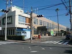 Aira City Hall | |||
| |||
|
Location of Aira in Kagoshima Prefecture | |||
 Aira Location in Japan | |||
| Coordinates: 31°45′N 130°46′E / 31.750°N 130.767°ECoordinates: 31°45′N 130°46′E / 31.750°N 130.767°E | |||
| Country | Japan | ||
| Region | Kyushu | ||
| Prefecture | Kagoshima Prefecture | ||
| Government | |||
| • Mayor | Yoshihiro Sasayama (since April 2010) | ||
| Area | |||
| • Total | 231.32 km2 (89.31 sq mi) | ||
| Population (October 1, 2016) | |||
| • Total | 75,665 | ||
| • Density | 323/km2 (840/sq mi) | ||
| Symbols | |||
| • Tree | Cinnamomum camphora | ||
| • Flower | Prunus jamasakura | ||
| Time zone | UTC+9 (JST) | ||
| City hall address |
25 Miyajima-cho, Aira-shi, Kagoshima-ken 899-5492 | ||
| Website |
www | ||
Aira (姶良市 Aira-shi) is a city located in Kagoshima Prefecture, Japan. It is located west of Kirishima and north of Kagoshima.
The modern city of Aira was established on March 23, 2010, from the merger of the former town of Aira, absorbing the towns of Kajiki and Kamō (all from Aira District).
As of May 2010, the city has an estimated population of 74,611 and a population density of 323 persons per km². The total area is 231.32 km².
It is accessed with the Kyushu Expressway at interchange 25, the Kajiki Interchange and interchange 26, the Aira Interchange. The expressway passed through Aira, connecting Kagoshima to the west and Kirishima to the North. The interchange was first opened on December 13, 1973. There are five railway stations in the city. From east to west, Kajiki, Kinkō, Chōsa, Aira and Shigetomi stations serve the city. All of these stations belong to Nippō Main Line, and are operated by Kyushu Railway Company (JR Kyushu).
Aira's claim to fame is a stone gate in the village of Yamada which commemorates the victory of the Russo-Japanese War.
The plan for the merger of the three towns was defeated twice. Once in 2005 and again in 2008. These defeats were due to a debt in public finance and the number of seats in the city council. Finally, in 2009, town representatives compromised with these problems and the merger plan was accepted. Aira District will be left with one municipality.[1]
References
- ↑ "Archived copy". Archived from the original on 2008-04-18. Retrieved 2008-09-13.
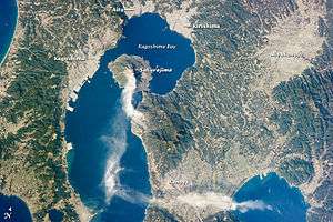
- ↑ Sakurajima Volcano, Kyushu, Japan - January 28, 2013
External links
- Aira City official website (in Japanese)
| Core city | |||||||||||
|---|---|---|---|---|---|---|---|---|---|---|---|
| Cities |
| ||||||||||
| Districts |
| ||||||||||