Aime
| Aime | ||
|---|---|---|
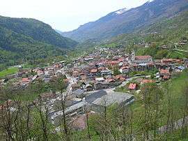 A general view of Aime | ||
| ||
 Aime Location within Auvergne-Rhône-Alpes region  Aime | ||
| Coordinates: 45°33′22″N 6°38′58″E / 45.5561°N 6.6494°ECoordinates: 45°33′22″N 6°38′58″E / 45.5561°N 6.6494°E | ||
| Country | France | |
| Region | Auvergne-Rhône-Alpes | |
| Department | Savoie | |
| Arrondissement | Albertville | |
| Canton | Bourg-Saint-Maurice | |
| Intercommunality | Versants Aime | |
| Government | ||
| • Mayor (-) | - | |
| Area1 | 50.74 km2 (19.59 sq mi) | |
| Population (2013)2 | 3,566 | |
| • Density | 70/km2 (180/sq mi) | |
| Time zone | UTC+1 (CET) | |
| • Summer (DST) | UTC+2 (CEST) | |
| INSEE/Postal code | 73006 /73210 | |
| Elevation |
596–2,589 m (1,955–8,494 ft) (avg. 680 m or 2,230 ft) | |
|
1 French Land Register data, which excludes lakes, ponds, glaciers > 1 km2 (0.386 sq mi or 247 acres) and river estuaries. 2 Population without double counting: residents of multiple communes (e.g., students and military personnel) only counted once. | ||

Aime is a former commune in the Savoie département in the Auvergne-Rhône-Alpes region in south-eastern France. On 1 January 2016, it was merged into the new commune of Aime-la-Plagne.[1] In 1972, the former communes of Longefoy, Tessens and Villette were merged with Aime.
Geography
The commune lies in the Tarentaise Valley, partly overlapping the ski resorts of La Plagne and Les Arcs.
Transportation
The town is served by the Aime-la-Plagne railway station.
See also
References
- ↑ Arrêté préfectoral 17 November 2015
| Wikimedia Commons has media related to Aime. |
This article is issued from
Wikipedia.
The text is licensed under Creative Commons - Attribution - Sharealike.
Additional terms may apply for the media files.