Ahu Tongariki

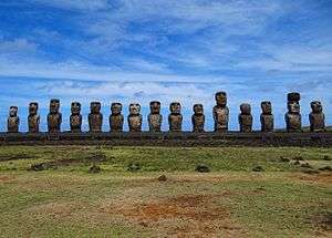

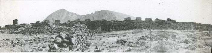
Ahu Tongariki is the largest ahu on Easter Island. Its moai were toppled during the island's civil wars and in the twentieth century the ahu was swept inland by a tsunami. It has since been restored and has fifteen moai including an 86 tonne moai that was the heaviest ever erected on the island. Ahu Tongariki is one kilometer from Rano Raraku and Poike in the Hotu-iti area of Rapa Nui National Park. All the moai here face sunset during Summer Solstice.
History
Ahu Tongariki was the main centre and capital of the Hotu Iti, the eastern confederation of the Rapanui.[1]
Its moai were toppled during the island's civil wars. In 1960, a tsunami caused by an earthquake off the coast of Chile swept the Ahu Tongariki inland.
Ahu Tongariki was substantially restored in the 1990s by a multidisciplinary team headed by archaeologists Claudio Cristino (Director) and Patricia Vargas (Co-director executive team), in a five-year project carried out under an official agreement of the Chilean Government with Tadano Limited and the University of Chile.
Location
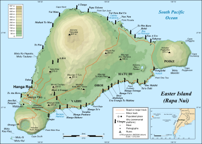
This ahu is on the south coast of Rapa Nui, close to two previous volcanoes, Rano Raraku and Poike.
Poike is one of the three main extinct volcanoes that form Rapa Nui, which last erupted between 230,000 and 705,000 years ago. Rano Raraku is a volcanic crater formed of consolidated volcanic ash or tuff, which compose the carved moai. Indeed, nearly half (hundreds) of the moai are still buried in the slopes of the Rano Raraku, the main moai quarry. The large, flat plain below Rano Raraku provided easy access to the tuff.
References
- Katherine Routledge (1919) The Mystery of Easter Island ISBN 0-932813-48-8
External links
| Wikimedia Commons has media related to Ahu Tongariki. |
- Splendid Isolation: Art of Easter Island, an exhibition catalog from The Metropolitan Museum of Art (fully available online as PDF), which contains material on Ahu Tongariki
- Ahu Tongariki Restoration project
- Unofficial Easter Island Homepage
- Easter Island Statue project
- How to make Walking Moai: a hypothesis about how Moai were transported
- Czech who made Moai statues walk returns to Easter Island
- History of Easter Island stones
- Easter Island - Moai Statue Scale
- University of Chile
- 360° Panoramas dedicated web site of Easter Island
Coordinates: 27°7′33″S 109°16′37″W / 27.12583°S 109.27694°W
| Culture |
|  | ||||
|---|---|---|---|---|---|---|
| Geography and geology | ||||||
| ||||||