Aguasay Municipality, Monagas
| Aguasay Municipality Municipio Aguasay | |
|---|---|
| Municipality | |
 Location in Monagas | |
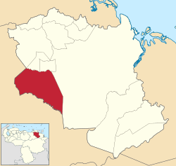
.svg.png) Aguasay Municipality Location in Venezuela | |
| Coordinates: 9°33′N 63°22′W / 9.55°N 63.37°WCoordinates: 9°33′N 63°22′W / 9.55°N 63.37°W | |
| Country |
|
| State | Monagas |
| Founded | 1987 |
| Government | |
| • Mayor | José Galindo (PSUV) |
| Population (2011) | |
| • Total | 11,771 |
| Time zone | UTC−04:00 (VET) |
Aguasay is one of the 13 municipalities of the state of Monagas, Venezuela.
History
In 1987 it is elevated to Municipality within the old Maturín District On September 27, 1994, it is separated from the Municipality of Maturín creating the Autonomous Municipality of Aguasay.
Geography
It is located to the west of the Monagas State, bordered to the north by the municipalities of Ezequiel Zamora and Santa Bárbara. The landscape is predominantly flat table, while it presents a tropical dry forest vegetation with an annual average temperature of 25.4°C and an average annual precipitation of 1,055 mm.
Economy
The oil exploitation in the municipality is relevant.
Culture
The town is famous for its fabric that is made from a plant that is grown in that town called Curagua.
Cuisine
A sweet that has stood out in Aguasay is the Moriche Ice Cream.[1]
Politics and government
Mayors
- José Galindo PSUV
References
- ↑ "Helado de moriche, más de medio siglo endulzando los más exigentes paladares" (in Spanish). 26 June 2017. Retrieved 8 July 2017.